IMAGES TAKEN NEAR TO
Neville Close, SLOUGH, SL2 4AQ
Introduction
This page details the photographs taken nearby to Neville Close, SL2 4AQ by members of the Geograph project.
The Geograph project started in 2005 with the aim of publishing, organising and preserving representative images for every square kilometre of Great Britain, Ireland and the Isle of Man.

There are currently over 7.5m images from over14,400 individuals and you can help contribute to the project by visiting https://www.geograph.org.uk
Image Map
Images are licensed for reuse under creativecommons.org/licenses/by-sa/2.0
Notes
- Clicking on the map will re-center to the selected point.
- The higher the marker number, the further away the image location is from the centre of the postcode.
Image Listing (9 Images Found)
Images are licensed for reuse under creativecommons.org/licenses/by-sa/2.0
Image
Details
Distance
1
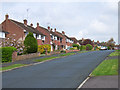
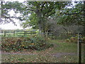
Hazell Way, Stoke Poges
Near the junction with Pennylets Green.
Image: © Andrew Smith
Taken: 30 Apr 2006
0.19 miles
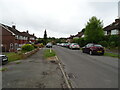
5
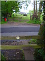
Beeches Way
Beeches Way leaving Stoke Common heading to Duffield Lane
Image: © Shaun Ferguson
Taken: 30 Oct 2012
0.23 miles
7
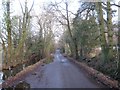
Stoke Poges: Duffield Lane
Heavy rain has caused the ditch at the side of the road to fill.
For a view in the opposite direction down this straight road please see Andrew's Image
Image: © Nigel Cox
Taken: 22 Dec 2013
0.23 miles
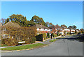
9
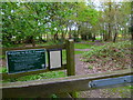
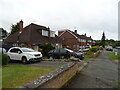
Beeches Way (46)
Stoke Common has a welcome notice.
Image: © Shazz
Taken: 17 May 2013
0.24 miles