IMAGES TAKEN NEAR TO
Andrew Hill Lane, SLOUGH, SL2 3UN
Introduction
This page details the photographs taken nearby to Andrew Hill Lane, SL2 3UN by members of the Geograph project.
The Geograph project started in 2005 with the aim of publishing, organising and preserving representative images for every square kilometre of Great Britain, Ireland and the Isle of Man.

There are currently over 7.5m images from over14,400 individuals and you can help contribute to the project by visiting https://www.geograph.org.uk
Image Map
Images are licensed for reuse under creativecommons.org/licenses/by-sa/2.0
Notes
- Clicking on the map will re-center to the selected point.
- The higher the marker number, the further away the image location is from the centre of the postcode.
Image Listing (4 Images Found)
Images are licensed for reuse under creativecommons.org/licenses/by-sa/2.0
Image
Details
Distance
1
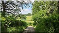
Andrew Hill Lane
Little used rural country lane.
Image: © James Emmans
Taken: 23 Jun 2021
0.09 miles
2
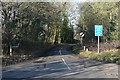
Hollybush Corner
The junction of Parish Lane, left to right, with Andrew Hill Lane, ahead. I am standing in Christmas Lane. There are some lovely unusual names around here.
Image: © Graham Horn
Taken: 23 Feb 2012
0.18 miles
4
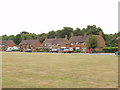
Jones Way across the green at Hedgerley Hill
This open grassland with a football pitch and children's play area has houses all around it, and the houses back onto woodland.
Image: © David Hawgood
Taken: 24 Jun 2005
0.24 miles