IMAGES TAKEN NEAR TO
Kestrel Path, SLOUGH, SL2 2NA
Introduction
This page details the photographs taken nearby to Kestrel Path, SL2 2NA by members of the Geograph project.
The Geograph project started in 2005 with the aim of publishing, organising and preserving representative images for every square kilometre of Great Britain, Ireland and the Isle of Man.

There are currently over 7.5m images from over14,400 individuals and you can help contribute to the project by visiting https://www.geograph.org.uk
Image Map
Images are licensed for reuse under creativecommons.org/licenses/by-sa/2.0
Notes
- Clicking on the map will re-center to the selected point.
- The higher the marker number, the further away the image location is from the centre of the postcode.
Image Listing (11 Images Found)
Images are licensed for reuse under creativecommons.org/licenses/by-sa/2.0
Image
Details
Distance
1
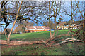
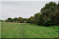
Park and Housing
The valley of a small stream has been kept undeveloped and makes a corridor of open space for a couple of kms in between the houses.
Image: © Des Blenkinsopp
Taken: 26 Nov 2018
0.03 miles
2
Lynch Hill Lane, Britwell
A sliver of countryside slices through the western end of the Britwell estate.
Image: © Andrew Smith
Taken: 30 Apr 2006
0.07 miles
3
Trees in the Park, Lynch Hill
The valley of a small stream, the Two Mile Brook, has been left undeveloped as a park in the midst of an area of suburban housing.
Image: © Des Blenkinsopp
Taken: 26 Nov 2018
0.07 miles
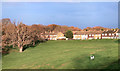
4
Lynch Hill
Housing beside Lynch Hill Lane.
Image: © Peter Trimming
Taken: 30 Oct 2024
0.11 miles
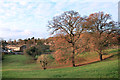
5
Lynch Hill
Lynch Hill Valley, a natural valley formed by Two Mile Brook which now flows through an underground conduit.
Image: © Peter Trimming
Taken: 30 Oct 2024
0.12 miles
6
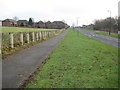
Lynch Hill: Whittaker Road
The concrete columns to the left of the footpath are anti-traveller barriers.
Image: © Nigel Cox
Taken: 9 Jan 2009
0.13 miles
7
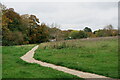
Lynch Hill
Footpath towards the Lynch Hill Valley.
Image: © Peter Trimming
Taken: 30 Oct 2024
0.14 miles
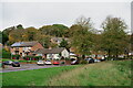
8
Unsettled Sunlight on Lynch Hill Lane
The Sun gets a look in as heavy grey clouds move off northwards. Lynch Hill Lane runs around the edge of a small valley with an intermittent stream at the bottom. There are houses on one side only. The valley is a mixture of grass and woodland and is a pleasant park.
Image: © Des Blenkinsopp
Taken: 26 Nov 2018
0.19 miles
9
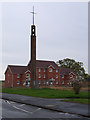
Long Furlong Drive, Britwell
The tower belongs to St George's church, which is hidden behind the new housing. That's a new development called Venus Close.
Image: © Andrew Smith
Taken: 30 Apr 2006
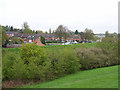
0.20 miles
10

Lower Britwell Road
The boundary of Slough Borough, a Unitary Authority, runs along the road here, Slough to the right, Buckinghamshire to the left.
Image: © Robin Webster
Taken: 26 Sep 2021
0.24 miles