IMAGES TAKEN NEAR TO
Sampsons Green, SLOUGH, SL2 2EF
Introduction
This page details the photographs taken nearby to Sampsons Green, SL2 2EF by members of the Geograph project.
The Geograph project started in 2005 with the aim of publishing, organising and preserving representative images for every square kilometre of Great Britain, Ireland and the Isle of Man.

There are currently over 7.5m images from over14,400 individuals and you can help contribute to the project by visiting https://www.geograph.org.uk
Image Map
Images are licensed for reuse under creativecommons.org/licenses/by-sa/2.0
Notes
- Clicking on the map will re-center to the selected point.
- The higher the marker number, the further away the image location is from the centre of the postcode.
Image Listing (9 Images Found)
Images are licensed for reuse under creativecommons.org/licenses/by-sa/2.0
Image
Details
Distance
3
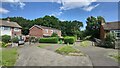
Public Footpath
Houses on the corner of Calbroke Road and Rokesby Road in Britwell, Slough.
Image: © James Emmans
Taken: 23 Jun 2021
0.13 miles
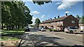
5
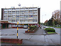
Wentworth Avenue, Britwell
Shops and flats at the run-down heart of the Britwell estate.
Image: © Andrew Smith
Taken: 30 Apr 2006
0.23 miles
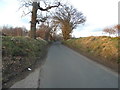
6
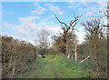
Crow Piece Lane
Crow Piece Lane runs from the edge of Burnham Beeches to the edge of the built up area on the north side of Slough.
It is mostly a surfaced road apart from the southern end which is closed to vehicles and is a footpath and bridleway only.
The surfaced section changes name to Walton Lane at a sharp bend.
Image: © Des Blenkinsopp
Taken: 26 Nov 2018
0.23 miles
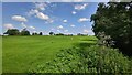
7
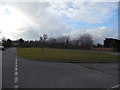
Cocksherd Wood
The northern end of a small valley which runs for around 2 kms of undeveloped reed bed, park and woodland in between the surrounding housing.
Image: © Des Blenkinsopp
Taken: 26 Nov 2018
0.24 miles
8
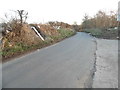
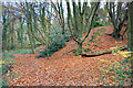
Walton Lane by Bottom Waltons camping site
There are signs up warning against flytipping and cameras set up to catch it but it's clearly made no difference, the place was spread with rubbish even though the council dump is just along the road.
Image: © David Howard
Taken: 8 Mar 2015
0.25 miles