IMAGES TAKEN NEAR TO
Crayle Street, SLOUGH, SL2 2AE
Introduction
This page details the photographs taken nearby to Crayle Street, SL2 2AE by members of the Geograph project.
The Geograph project started in 2005 with the aim of publishing, organising and preserving representative images for every square kilometre of Great Britain, Ireland and the Isle of Man.

There are currently over 7.5m images from over14,400 individuals and you can help contribute to the project by visiting https://www.geograph.org.uk
Image Map
Images are licensed for reuse under creativecommons.org/licenses/by-sa/2.0
Notes
- Clicking on the map will re-center to the selected point.
- The higher the marker number, the further away the image location is from the centre of the postcode.
Image Listing (5 Images Found)
Images are licensed for reuse under creativecommons.org/licenses/by-sa/2.0
Image
Details
Distance
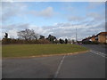
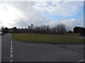
2

Farnham Lane, Farnham Royal
Opposite the rugby pitch
Image: © David Howard
Taken: 8 Mar 2015
0.19 miles
4
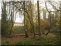
Boundary Copse
A view in the northern end of Image, with housing on Bishop's Orchard in the background, and one of the dried-up ponds referred to at http://www.woodlandtrust.org.uk/en/our-woods/Pages/about-this-wood.aspx?wood=4359 .
Image: © Derek Harper
Taken: 19 Nov 2010
0.24 miles
5
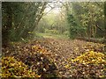
Boundary Copse
From the Woodland Trust site at http://www.woodlandtrust.org.uk/en/our-woods/Pages/wood-details.aspx?wood=4359 : "a 1.23ha woodland acquired from South Bucks District Council in 1989 ... The woodland originated from the remains of a large private garden". These piles of leaves have been gathered at the northern A355 entrance.
Image: © Derek Harper
Taken: 19 Nov 2010
0.24 miles