IMAGES TAKEN NEAR TO
Poyle Lane, SLOUGH, SL1 8LD
Introduction
This page details the photographs taken nearby to Poyle Lane, SL1 8LD by members of the Geograph project.
The Geograph project started in 2005 with the aim of publishing, organising and preserving representative images for every square kilometre of Great Britain, Ireland and the Isle of Man.

There are currently over 7.5m images from over14,400 individuals and you can help contribute to the project by visiting https://www.geograph.org.uk
Image Map
Images are licensed for reuse under creativecommons.org/licenses/by-sa/2.0
Notes
- Clicking on the map will re-center to the selected point.
- The higher the marker number, the further away the image location is from the centre of the postcode.
Image Listing (5 Images Found)
Images are licensed for reuse under creativecommons.org/licenses/by-sa/2.0
Image
Details
Distance
1
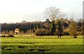
Meadowland, Burnham (Bucks)
Taken from Brickfield Lane looking north-west.
Image: © David Kemp
Taken: 12 Jan 2006
0.19 miles
2
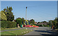
Colourful Roadworks, Pink Lane
Pink Lane, Burnham.
Keeping the colour thing going, it is currently home to the red, orange, yellow and blue of a small works site.
And a green wheely bin.
Image: © Des Blenkinsopp
Taken: 7 Sep 2023
0.21 miles
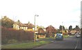
3
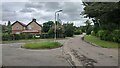
Poyle Lane junction with Grenville Close
View from the end of the narrow public footpath.
Image: © James Emmans
Taken: 19 Jun 2021
0.21 miles
5
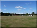
Pink Lane, Burnham (Bucks)
Taken halfway down Pink Lane looking east. Residential areas such as this are typical of the area.
Image: © David Kemp
Taken: 12 Jan 2006
0.25 miles