IMAGES TAKEN NEAR TO
Minniecroft Road, SLOUGH, SL1 7DE
Introduction
This page details the photographs taken nearby to Minniecroft Road, SL1 7DE by members of the Geograph project.
The Geograph project started in 2005 with the aim of publishing, organising and preserving representative images for every square kilometre of Great Britain, Ireland and the Isle of Man.

There are currently over 7.5m images from over14,400 individuals and you can help contribute to the project by visiting https://www.geograph.org.uk
Image Map
Images are licensed for reuse under creativecommons.org/licenses/by-sa/2.0
Notes
- Clicking on the map will re-center to the selected point.
- The higher the marker number, the further away the image location is from the centre of the postcode.
Image Listing (37 Images Found)
Images are licensed for reuse under creativecommons.org/licenses/by-sa/2.0
Image
Details
Distance
3
Clonmel Way, Burnham (Bucks)
There are several roads of terraced housing in this gridsquare dating from the mid-nineteenth century to the second half of the twentieth. Clonmel Way, seen here looking north-east, is an example of the latter.
Image: © David Kemp
Taken: 12 Jan 2006
0.12 miles
4
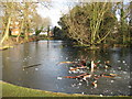
Burnham: Lent Green Pond
Give certain members of the public a frozen pond and the temptation to test the thickness, hardness and slipperiness of the ice is too much. Here a set of dining chairs fails to break the ice while further out a yellow and black kiddy's bicycle and an orange plastic bread basket are also still on the surface.
This pond is shown with more or less the same shape on the 1882 Ordnance Survey map.
Image: © Nigel Cox
Taken: 9 Jan 2009
0.13 miles
7
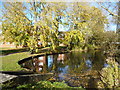
Lent Green Pond
An autumn view of this small pond in the middle of the houses, though I can't match the garbage level displayed in this picture of the same place in winter. Image
Image: © Des Blenkinsopp
Taken: 15 Nov 2013
0.15 miles
8
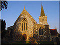
Burnham Parish Church - St Peters
The village of Burnham was mentioned in the Domesday Book. And the first church was probably built about 500 AD. The present building was probably started in the 12th Century.
Image: © Linda Bailey
Taken: 20 Oct 2005
0.16 miles
9
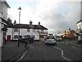
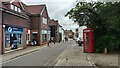
Britwell Road at the junction of High Street Burnham
Image: © David Howard
Taken: 8 Mar 2015
0.16 miles
10
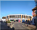
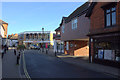
Tesco Schmessco
Burnham High Street is mostly a pleasant mixture of old buildings of various ages.
There may well be those who consider this one is an unsympathetic addition.
Image: © Des Blenkinsopp
Taken: 15 Nov 2013
0.16 miles