IMAGES TAKEN NEAR TO
The Green, SLOUGH, SL1 7BG
Introduction
This page details the photographs taken nearby to The Green, SL1 7BG by members of the Geograph project.
The Geograph project started in 2005 with the aim of publishing, organising and preserving representative images for every square kilometre of Great Britain, Ireland and the Isle of Man.

There are currently over 7.5m images from over14,400 individuals and you can help contribute to the project by visiting https://www.geograph.org.uk
Image Map
Images are licensed for reuse under creativecommons.org/licenses/by-sa/2.0
Notes
- Clicking on the map will re-center to the selected point.
- The higher the marker number, the further away the image location is from the centre of the postcode.
Image Listing (10 Images Found)
Images are licensed for reuse under creativecommons.org/licenses/by-sa/2.0
Image
Details
Distance
1
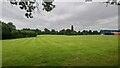
Burnham Park Academy sports grounds
The school closed in 2019 but the fields are still being maintained.
Image: © James Emmans
Taken: 19 Jun 2021
0.06 miles
2
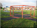
Burnham: St Peter's Recreation Ground
The Council notice board describes this as an "Unsupervised Mixed Age Group Play Area Suitable for children up to 14 years".
Image: © Nigel Cox
Taken: 9 Jan 2009
0.12 miles
4
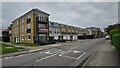
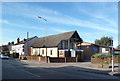
Infill residential development on Stomp Road
A Chancery branded Octagon project probably built on school land.
Image: © James Emmans
Taken: 19 Jun 2021
0.16 miles
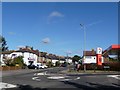
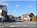
5
Burnham Church and Lent Rise Road from Boundary Road
Image: © Kevin White
Taken: 22 Sep 2009
0.17 miles
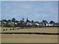
7
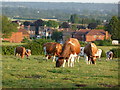
Hitcham Farm Ayrshires,from farm footpath view to Milner Road houses
Image: © Kevin White
Taken: 30 Jun 2008
0.22 miles
8
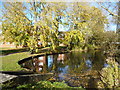
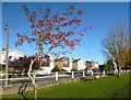
Lent Green Pond
An autumn view of this small pond in the middle of the houses, though I can't match the garbage level displayed in this picture of the same place in winter. Image
Image: © Des Blenkinsopp
Taken: 15 Nov 2013
0.24 miles