IMAGES TAKEN NEAR TO
Walpole Road, SLOUGH, SL1 6PA
Introduction
This page details the photographs taken nearby to Walpole Road, SL1 6PA by members of the Geograph project.
The Geograph project started in 2005 with the aim of publishing, organising and preserving representative images for every square kilometre of Great Britain, Ireland and the Isle of Man.

There are currently over 7.5m images from over14,400 individuals and you can help contribute to the project by visiting https://www.geograph.org.uk
Image Map
Images are licensed for reuse under creativecommons.org/licenses/by-sa/2.0
Notes
- Clicking on the map will re-center to the selected point.
- The higher the marker number, the further away the image location is from the centre of the postcode.
Image Listing (23 Images Found)
Images are licensed for reuse under creativecommons.org/licenses/by-sa/2.0
Image
Details
Distance
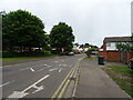
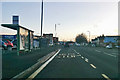
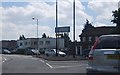
2
Junction of the A4 with St Andrew's Way
There is a service road on the left of the A4.
Image: © Shazz
Taken: 17 May 2013
0.11 miles
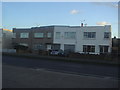
3
Modernist houses on Bath Road, Burnham
I've passed this way many times and never noticed these before.
Image: © David Howard
Taken: 8 Jan 2018
0.12 miles
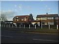
4
Modernist houses on Bath Road, Burnham
Image: © David Howard
Taken: 19 Feb 2012
0.13 miles
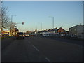
7
A4 towards Slough town centre
At the St Andrews Way bus stop.
Image: © Robin Webster
Taken: 7 Jan 2018
0.15 miles
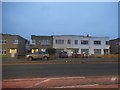
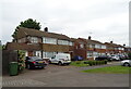
9
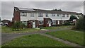
Modern terrace housing on Goldsworthy Way
Image: © James Emmans
Taken: 19 Jun 2021
0.15 miles