IMAGES TAKEN NEAR TO
Lawrence Way, SLOUGH, SL1 6HH
Introduction
This page details the photographs taken nearby to Lawrence Way, SL1 6HH by members of the Geograph project.
The Geograph project started in 2005 with the aim of publishing, organising and preserving representative images for every square kilometre of Great Britain, Ireland and the Isle of Man.

There are currently over 7.5m images from over14,400 individuals and you can help contribute to the project by visiting https://www.geograph.org.uk
Image Map
Images are licensed for reuse under creativecommons.org/licenses/by-sa/2.0
Notes
- Clicking on the map will re-center to the selected point.
- The higher the marker number, the further away the image location is from the centre of the postcode.
Image Listing (3 Images Found)
Images are licensed for reuse under creativecommons.org/licenses/by-sa/2.0
Image
Details
Distance
1
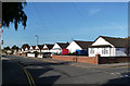
Royston Way, Burnham
Low rise housing all along here.
Image: © Des Blenkinsopp
Taken: 15 Nov 2013
0.13 miles
2
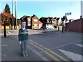
Figure at the Crossing
This lifesize model child is at the end of Orchard Avenue which leads to a school.
Image: © Des Blenkinsopp
Taken: 15 Nov 2013
0.21 miles
3
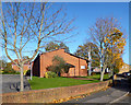
Mormon Church, Leaholme Gardens
The Church of Jesus Christ of Latter Day Saints, to give the full title.
Image: © Des Blenkinsopp
Taken: 15 Nov 2013
0.25 miles