IMAGES TAKEN NEAR TO
Royston Way, SLOUGH, SL1 6HF
Introduction
This page details the photographs taken nearby to Royston Way, SL1 6HF by members of the Geograph project.
The Geograph project started in 2005 with the aim of publishing, organising and preserving representative images for every square kilometre of Great Britain, Ireland and the Isle of Man.

There are currently over 7.5m images from over14,400 individuals and you can help contribute to the project by visiting https://www.geograph.org.uk
Image Map
Images are licensed for reuse under creativecommons.org/licenses/by-sa/2.0
Notes
- Clicking on the map will re-center to the selected point.
- The higher the marker number, the further away the image location is from the centre of the postcode.
Image Listing (6 Images Found)
Images are licensed for reuse under creativecommons.org/licenses/by-sa/2.0
Image
Details
Distance
1
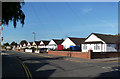
Royston Way, Burnham
Low rise housing all along here.
Image: © Des Blenkinsopp
Taken: 15 Nov 2013
0.08 miles
2
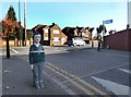
Figure at the Crossing
This lifesize model child is at the end of Orchard Avenue which leads to a school.
Image: © Des Blenkinsopp
Taken: 15 Nov 2013
0.21 miles
3
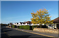
Royston Way, Burnham
Low rise housing all along here.
Image: © Des Blenkinsopp
Taken: 15 Nov 2013
0.21 miles
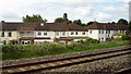
4
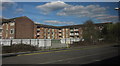
Sandringham Court, Burnham
Blocks of flats behind Burnham station, seen from a train leaving the station for Taplow, hence the reflections.
Image: © Derek Harper
Taken: 19 Mar 2012
0.24 miles
5
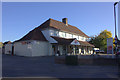
Tesco Express at the junction of Burnham Lane and Haymill Rd
Image: © Robert Eva
Taken: 6 Oct 2017
0.24 miles
6
Houses, Burnham
On Stanhope Road, and the other side of the railway line from Image
Image: © Derek Harper
Taken: 3 Jun 2019
0.24 miles