IMAGES TAKEN NEAR TO
Stoke Gardens, SLOUGH, SL1 3QD
Introduction
This page details the photographs taken nearby to Stoke Gardens, SL1 3QD by members of the Geograph project.
The Geograph project started in 2005 with the aim of publishing, organising and preserving representative images for every square kilometre of Great Britain, Ireland and the Isle of Man.

There are currently over 7.5m images from over14,400 individuals and you can help contribute to the project by visiting https://www.geograph.org.uk
Image Map
Images are licensed for reuse under creativecommons.org/licenses/by-sa/2.0
Notes
- Clicking on the map will re-center to the selected point.
- The higher the marker number, the further away the image location is from the centre of the postcode.
Image Listing (141 Images Found)
Images are licensed for reuse under creativecommons.org/licenses/by-sa/2.0
Image
Details
Distance
1
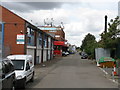
Slough - Bristol Way
An access road off Stoke Gardens.
Image: © Peter Whatley
Taken: 17 Jul 2010
0.05 miles
2
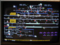
Slough New signalbox - detail screen
This screen shows a detailed view of the Southall area, having been called up as described in http://www.geograph.org.uk/photo/1967932. Train 1T55 has just passed Southall station. The signaller has made all signal, point and track circuit information display, though normally these would be called up selectively depending on signalling needs. In addition, some items have been highlighted to demonstrate the capability to block use of facilities or highlight that a specific action is required.
Photograph taken under the supervision of Network Rail management.
Image: © Peter Whatley
Taken: 17 Jul 2010
0.05 miles
3
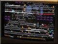
Slough New signalbox - overview screen
An example of the computer-based screen and control system in use at Slough New signalbox. In this system, the signaller sees one or more screens providing an overview of his/her control area, on which there is a minimum of information necessary to monitor the progress of trains. Signalling and route-setting for trains is normally fully automatic by computer, based on the timetable for the area. Note that while trains' positions are shown (red lines on the screen) complete with their signalling identity tags (e.g. 1T55), other information is either abbreviated (e.g. SL for Southall which 1T55 is approaching) or absent. There are, for example, no signal, point or track circuit numbers shown. That information can be readily displayed by calling up a more detailed screen from the computer, such as http://www.geograph.org.uk/photo/1967948.
Photograph taken under the supervision of Network Rail management.
Image: © Peter Whatley
Taken: 17 Jul 2010
0.05 miles
4
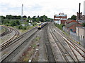
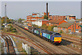
Up HST approaching Slough
A London-bound train approaches Slough at speed on the Up Main line. The Windsor branch curves off to the left. The single-storey brick building on the right is Slough New signalbox (for details, see: http://www.geograph.org.uk/photo/1967902).
Image: © Peter Whatley
Taken: 17 Jul 2010
0.08 miles
5
Excursion Train at Slough
Special charter train rushing through Slough.
Image: © Wayland Smith
Taken: 23 Oct 2011
0.08 miles
6
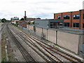
Slough Signalboxes
The twin signalboxes at Slough control the main line from London Paddington to west of Maindenhead. The two-storey building nearest the camera (Slough Panel Signal Box) opened in 1963 to control the area around Slough itself, replacing 13 conventional manual signalboxes. It uses a British Rail (Western Region) entrance-exit (NX) panel which is now (2010) showing its age somewhat. The large brick base section was designed to house electro-mechanical relays, but with steady reduction in those devices' size has had ample room to also house the computer-based interlocking for Slough New signalbox. That installation's operating facilities are housed in the small bungalow-like structure beyond the 1963 structure. Slough New was opened in stages between 1992 and 1995, replacing Old Oak Common signalbox and adding the new lines to Heathrow. Slough New is a fully computerised facility with Automatic Route Setting (ARS) which can, in theory, eliminate the need for signalling staff. In practice, signallers remain essential for periods of traffic perturbation. For examples of the signalling system in Slough New, see: http://www.geograph.org.uk/photo/1967932 and http://www.geograph.org.uk/photo/1967948.
Both signalboxes are due to close in 2011, to be replaced by a centralised facility for Thames Valley services at Didcot.
Image: © Peter Whatley
Taken: 17 Jul 2010
0.08 miles
9
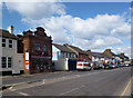
Stoke Road, Slough
The Chicken Ranch building was built in 1882 as The Leopold Coffee House. The name and date are still on the facade in the brickwork.
The idea behind it was the classic Victorian one of enticing drinkers away from the wickedness of the pubs.
http://www.sloughhistoryonline.org.uk/ixbin/hixclient.exe?a=query&p=slough&f=generic_objectrecord_postsearch.htm&_IXFIRST_=2269&_IXMAXHITS_=1&m=quick_sform&tc1=i&partner=slough&s=ZXLdrkpbHiD
Strangely, all these years later, a decent coffee could still pull that trick for me sometimes. Fried chicken couldn't.
Image: © Des Blenkinsopp
Taken: 14 Mar 2013
0.10 miles
10
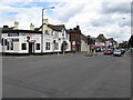
Slough - the 2nd Stop pub
At the corner of Stoke Gardens and Stoke Road.
Image: © Peter Whatley
Taken: 17 Jul 2010
0.10 miles