IMAGES TAKEN NEAR TO
Love Green Lane, IVER, SL0 9RA
Introduction
This page details the photographs taken nearby to Love Green Lane, SL0 9RA by members of the Geograph project.
The Geograph project started in 2005 with the aim of publishing, organising and preserving representative images for every square kilometre of Great Britain, Ireland and the Isle of Man.

There are currently over 7.5m images from over14,400 individuals and you can help contribute to the project by visiting https://www.geograph.org.uk
Image Map
Images are licensed for reuse under creativecommons.org/licenses/by-sa/2.0
Notes
- Clicking on the map will re-center to the selected point.
- The higher the marker number, the further away the image location is from the centre of the postcode.
Image Listing (13 Images Found)
Images are licensed for reuse under creativecommons.org/licenses/by-sa/2.0
Image
Details
Distance
2
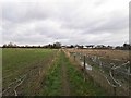
Shakespeare's Way National Footpath
Footpath through a field near Love Green.
Image: © James Emmans
Taken: 9 Jan 2019
0.04 miles
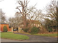
3
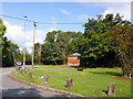
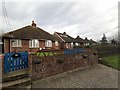
Love Green
The small green giving its name to the settlement here.
Image: © Robin Webster
Taken: 21 Sep 2014
0.04 miles
4
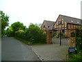
Beeches Way (80)
The way to go is by Love Green Farm.
Image: © Shazz
Taken: 21 May 2013
0.05 miles
5
Beeches Way (79)
This is Swallow Street at Love Green.
Image: © Shazz
Taken: 21 May 2013
0.05 miles
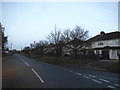
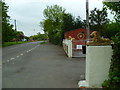
6
Love Green, Iver
From the junction of Street Lane and Love Green Lane, looking north-east.
Image: © David Hawgood
Taken: 17 Jan 2006
0.05 miles
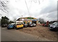
7
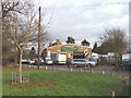
Love Green Garage, near Iver
In Love Green Lane
Image: © David Hawgood
Taken: 17 Jan 2006
0.05 miles
9
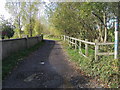
Beeches Way
Off Swallow Street the Beeches Way following the bridleway heading to Wood Lane
Image: © Shaun Ferguson
Taken: 30 Oct 2012
0.12 miles