IMAGES TAKEN NEAR TO
Grange Way, IVER, SL0 9NT
Introduction
This page details the photographs taken nearby to Grange Way, SL0 9NT by members of the Geograph project.
The Geograph project started in 2005 with the aim of publishing, organising and preserving representative images for every square kilometre of Great Britain, Ireland and the Isle of Man.

There are currently over 7.5m images from over14,400 individuals and you can help contribute to the project by visiting https://www.geograph.org.uk
Image Map
Images are licensed for reuse under creativecommons.org/licenses/by-sa/2.0
Notes
- Clicking on the map will re-center to the selected point.
- The higher the marker number, the further away the image location is from the centre of the postcode.
Image Listing (54 Images Found)
Images are licensed for reuse under creativecommons.org/licenses/by-sa/2.0
Image
Details
Distance
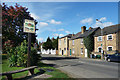
1
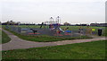
Iver Park and Recreation Ground, Iver
Those were the days!
Image: © Rob Emms
Taken: 2 Dec 2016
0.14 miles
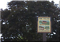
2
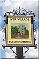
Iver - village sign
The artist has chosen St Peter's Church to illustrate Iver village.
Image: © Stephen McKay
Taken: 15 Aug 2017
0.14 miles
3
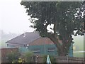
Iver: a summer's day
Iver Buckinghamshire on a rainy summer's day in 2015.
Image: © Rob Emms
Taken: 26 Aug 2015
0.14 miles
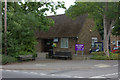
4
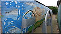
Youth artwork on brick wall
Council authorised artwork, by entrance into Iver Park and Recreation Ground.
Image: © Rob Emms
Taken: 2 Dec 2016
0.14 miles
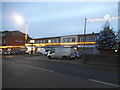
6
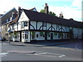
The Swan Public House in Iver Village
17th century pub & restaurant opposite St Peter's Church.
Image: © John Chisholm
Taken: Unknown
0.15 miles