IMAGES TAKEN NEAR TO
Chequers Orchard, IVER, SL0 9NL
Introduction
This page details the photographs taken nearby to Chequers Orchard, SL0 9NL by members of the Geograph project.
The Geograph project started in 2005 with the aim of publishing, organising and preserving representative images for every square kilometre of Great Britain, Ireland and the Isle of Man.

There are currently over 7.5m images from over14,400 individuals and you can help contribute to the project by visiting https://www.geograph.org.uk
Image Map
Images are licensed for reuse under creativecommons.org/licenses/by-sa/2.0
Notes
- Clicking on the map will re-center to the selected point.
- The higher the marker number, the further away the image location is from the centre of the postcode.
Image Listing (72 Images Found)
Images are licensed for reuse under creativecommons.org/licenses/by-sa/2.0
Image
Details
Distance
1
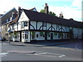
The Swan Public House in Iver Village
17th century pub & restaurant opposite St Peter's Church.
Image: © John Chisholm
Taken: Unknown
0.09 miles
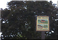
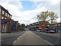
6
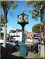
Iver Clock
Outside a row of shops along the High Street.
Image: © Des Blenkinsopp
Taken: 5 Oct 2017
0.09 miles
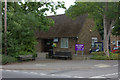
10
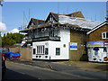
The Chequers, Iver (closed)
Building work is in hand, it looks like it is being changed into something else.
Image: © Robin Webster
Taken: 21 Sep 2014
0.11 miles