IMAGES TAKEN NEAR TO
High Street, IVER, SL0 9NG
Introduction
This page details the photographs taken nearby to High Street, SL0 9NG by members of the Geograph project.
The Geograph project started in 2005 with the aim of publishing, organising and preserving representative images for every square kilometre of Great Britain, Ireland and the Isle of Man.

There are currently over 7.5m images from over14,400 individuals and you can help contribute to the project by visiting https://www.geograph.org.uk
Image Map
Images are licensed for reuse under creativecommons.org/licenses/by-sa/2.0
Notes
- Clicking on the map will re-center to the selected point.
- The higher the marker number, the further away the image location is from the centre of the postcode.
Image Listing (75 Images Found)
Images are licensed for reuse under creativecommons.org/licenses/by-sa/2.0
Image
Details
Distance
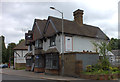
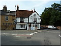
1
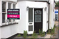
The Chequers, Iver
No longer a warm welcome it would seem.
Image: © Robert Eva
Taken: 22 Jun 2017
0.01 miles
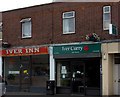
6
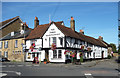
The Swan, Iver
The other side of the cross roads from St Peter's Church. Iver's village pub from way back before suburbs were even thought of.
Image: © Des Blenkinsopp
Taken: 5 Oct 2017
0.04 miles
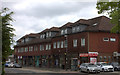
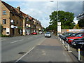
10
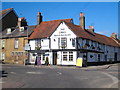
The Swan public house
Dating from the C16th and Grade II listed http://www.imagesofengland.org.uk/Details/Default.aspx?id=44156&mode=adv.
Image: © Rod Allday
Taken: 7 Mar 2010
0.05 miles