IMAGES TAKEN NEAR TO
Palmers Moor Lane, IVER, SL0 9LG
Introduction
This page details the photographs taken nearby to Palmers Moor Lane, SL0 9LG by members of the Geograph project.
The Geograph project started in 2005 with the aim of publishing, organising and preserving representative images for every square kilometre of Great Britain, Ireland and the Isle of Man.

There are currently over 7.5m images from over14,400 individuals and you can help contribute to the project by visiting https://www.geograph.org.uk
Image Map
Images are licensed for reuse under creativecommons.org/licenses/by-sa/2.0
Notes
- Clicking on the map will re-center to the selected point.
- The higher the marker number, the further away the image location is from the centre of the postcode.
Image Listing (21 Images Found)
Images are licensed for reuse under creativecommons.org/licenses/by-sa/2.0
Image
Details
Distance
1
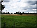
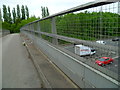
Farm Land near Palmer's Moor Farm
M25 runs hidden along the horizon only 500m away.
Image: © James Emmans
Taken: 2 Aug 2019
0.09 miles
3
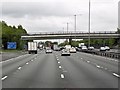
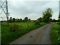
Palmer's Moor Farm
Bridge in distance crosses M25
Image: © Ray Stanton
Taken: 21 Dec 2005
0.12 miles
4

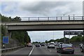
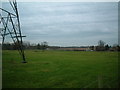
Anti-clockwise M25 near Palmers Moor Farm
Image: © David Dixon
Taken: 13 May 2013
0.14 miles