IMAGES TAKEN NEAR TO
Thorney Mill Road, IVER, SL0 9AH
Introduction
This page details the photographs taken nearby to Thorney Mill Road, SL0 9AH by members of the Geograph project.
The Geograph project started in 2005 with the aim of publishing, organising and preserving representative images for every square kilometre of Great Britain, Ireland and the Isle of Man.

There are currently over 7.5m images from over14,400 individuals and you can help contribute to the project by visiting https://www.geograph.org.uk
Image Map
Images are licensed for reuse under creativecommons.org/licenses/by-sa/2.0
Notes
- Clicking on the map will re-center to the selected point.
- The higher the marker number, the further away the image location is from the centre of the postcode.
Image Listing (33 Images Found)
Images are licensed for reuse under creativecommons.org/licenses/by-sa/2.0
Image
Details
Distance

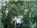
2
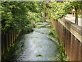
Colne Brook
North, upstream, of Thorney Mill Road.
Image: © Robin Webster
Taken: 10 Jun 2017
0.04 miles
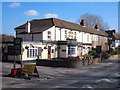
4
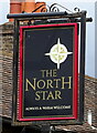
Sign for the North Star, Iver
See Image] for context.
Image: © JThomas
Taken: 23 May 2022
0.08 miles
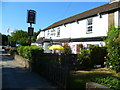
6
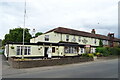
The North Star, Iver
On Thorney Mill Road.
See Image] for sign.
Image: © JThomas
Taken: 23 May 2022
0.09 miles
7
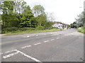
Thorney Mill Road
The buildings on the right are pretty much the whole of Thorney village.
Image: © David Howard
Taken: 11 May 2014
0.09 miles
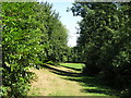
9
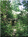
Mildly overgrown stile on a path north of Thorney Mill Road
Image: © Mike Quinn
Taken: 5 Jul 2017
0.10 miles
10
The Colne Brook southeast of Thorney Farm
Image: © Mike Quinn
Taken: 5 Jul 2017
0.10 miles