IMAGES TAKEN NEAR TO
Cedar Close, IVER, SL0 0QX
Introduction
This page details the photographs taken nearby to Cedar Close, SL0 0QX by members of the Geograph project.
The Geograph project started in 2005 with the aim of publishing, organising and preserving representative images for every square kilometre of Great Britain, Ireland and the Isle of Man.

There are currently over 7.5m images from over14,400 individuals and you can help contribute to the project by visiting https://www.geograph.org.uk
Image Map
Images are licensed for reuse under creativecommons.org/licenses/by-sa/2.0
Notes
- Clicking on the map will re-center to the selected point.
- The higher the marker number, the further away the image location is from the centre of the postcode.
Image Listing (17 Images Found)
Images are licensed for reuse under creativecommons.org/licenses/by-sa/2.0
Image
Details
Distance
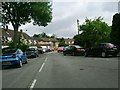
1

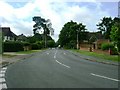
Pinewood Green
The Pinewood Green housing estate in Iver Heath.
Image: © Ajay Tegala
Taken: 4 Dec 2005
0.06 miles
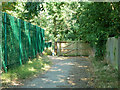
3
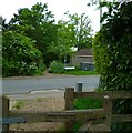
Footpath crosses the road called Pinewood Green
Image: © Shazz
Taken: 21 May 2013
0.07 miles
4
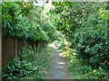
Public footpath towards Pinewood Road
Behind the back gardens of houses on Pinewood Green.
Image: © Robin Webster
Taken: 21 Jul 2013
0.09 miles
5
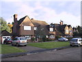
Pinewood Close
Pinewood Close, near Pinewood Studios, Iver Heath.
Image: © Ajay Tegala
Taken: 4 Dec 2005
0.10 miles
7
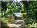
Public footpath towards Pinewood Road
The final section beyond the near trees is a short road on the housing estate here.
Image: © Robin Webster
Taken: 21 Jul 2013
0.14 miles
8
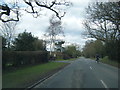
Pinewood Road at Park Lodge Farm entrance
Image: © Colin Pyle
Taken: 28 Feb 2016
0.15 miles
10
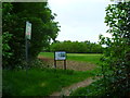
Black Park Link Path
A link between the country park and Pinewood Road, which is behind the gates. The sign suggests it is courtesy of Pinewood Studios.
Image: © Robin Webster
Taken: 21 Jul 2013
0.16 miles