IMAGES TAKEN NEAR TO
Ashford Road, IVER, SL0 0QF
Introduction
This page details the photographs taken nearby to Ashford Road, SL0 0QF by members of the Geograph project.
The Geograph project started in 2005 with the aim of publishing, organising and preserving representative images for every square kilometre of Great Britain, Ireland and the Isle of Man.

There are currently over 7.5m images from over14,400 individuals and you can help contribute to the project by visiting https://www.geograph.org.uk
Image Map
Images are licensed for reuse under creativecommons.org/licenses/by-sa/2.0
Notes
- Clicking on the map will re-center to the selected point.
- The higher the marker number, the further away the image location is from the centre of the postcode.
Image Listing (16 Images Found)
Images are licensed for reuse under creativecommons.org/licenses/by-sa/2.0
Image
Details
Distance
3

Pinewood Green
The Pinewood Green housing estate in Iver Heath.
Image: © Ajay Tegala
Taken: 4 Dec 2005
0.11 miles
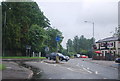
5
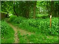
Footpath crosses the road called Pinewood Green
Image: © Shazz
Taken: 21 May 2013
0.13 miles
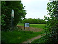
6
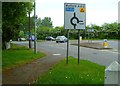
Roundabout on Denham Road with footpath on left
Image: © Shazz
Taken: 21 May 2013
0.19 miles
9
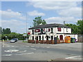
Stag & Hounds, Iver Heath
The Stag & Hounds pub in Iver Heath. In the foreground is a mini-roundabout.
Image: © Malc McDonald
Taken: 2 Jun 2013
0.20 miles
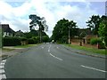
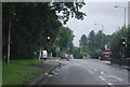
10
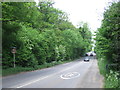
Denham Road, Iver Heath
Denham Road is the A412. Here the speed limit rises from 30mph to 50mph as the road leaves the village of Iver Heath.
Image: © Malc McDonald
Taken: 2 Jun 2013
0.20 miles