IMAGES TAKEN NEAR TO
Bellswood Lane, IVER, SL0 0LX
Introduction
This page details the photographs taken nearby to Bellswood Lane, SL0 0LX by members of the Geograph project.
The Geograph project started in 2005 with the aim of publishing, organising and preserving representative images for every square kilometre of Great Britain, Ireland and the Isle of Man.

There are currently over 7.5m images from over14,400 individuals and you can help contribute to the project by visiting https://www.geograph.org.uk
Image Map
Images are licensed for reuse under creativecommons.org/licenses/by-sa/2.0
Notes
- Clicking on the map will re-center to the selected point.
- The higher the marker number, the further away the image location is from the centre of the postcode.
Image Listing (19 Images Found)
Images are licensed for reuse under creativecommons.org/licenses/by-sa/2.0
Image
Details
Distance
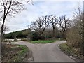
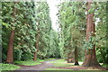
6
Treal Farm, Langley Park
The path on the right is Beeches Way, going west into Langley Park.
Image: © David Hawgood
Taken: 17 Jan 2006
0.17 miles
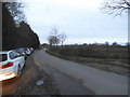
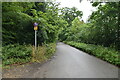
8
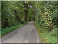
Bellswood Lane, Iver
Bellswood Lane near the junction with Wood Lane.
Image: © Alan Hunt
Taken: 13 Oct 2012
0.19 miles
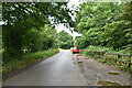
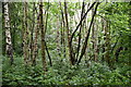
9

Beeches Way (77)
This is the somewhat unsavoury exit from Langley Park.
Image: © Shazz
Taken: 21 May 2013
0.20 miles