IMAGES TAKEN NEAR TO
Billet Lane, IVER, SL0 0LS
Introduction
This page details the photographs taken nearby to Billet Lane, SL0 0LS by members of the Geograph project.
The Geograph project started in 2005 with the aim of publishing, organising and preserving representative images for every square kilometre of Great Britain, Ireland and the Isle of Man.

There are currently over 7.5m images from over14,400 individuals and you can help contribute to the project by visiting https://www.geograph.org.uk
Image Map
Images are licensed for reuse under creativecommons.org/licenses/by-sa/2.0
Notes
- Clicking on the map will re-center to the selected point.
- The higher the marker number, the further away the image location is from the centre of the postcode.
Image Listing (41 Images Found)
Images are licensed for reuse under creativecommons.org/licenses/by-sa/2.0
Image
Details
Distance
1
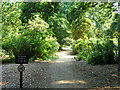
Path into the Temple Gardens
A more formal part of Langley Park country park.
Image: © Robin Webster
Taken: 21 Jul 2013
0.06 miles
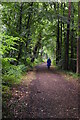
2

Beeches Way (76)
The rhododendrons in Langley Park are magnificent.
Image: © Shazz
Taken: 21 May 2013
0.06 miles
3

Beeches Way (75)
Here's a view in the rhododendron garden in Langley Park.
Image: © Shazz
Taken: 21 May 2013
0.07 miles
4
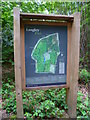
Beeches Way (74)
Here is the welcoming notice in Langley Park Country Park.
Image: © Shazz
Taken: 21 May 2013
0.07 miles

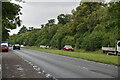
6

Beeches Way (73)
The A412 must be crossed here to get from one country park to the next.
Image: © Shazz
Taken: 21 May 2013
0.08 miles

10
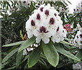
Rhododendron flower, Temple Gardens, Langley Park
Image: © David Hawgood
Taken: 26 May 2015
0.10 miles