IMAGES TAKEN NEAR TO
Wood Lane, IVER, SL0 0LD
Introduction
This page details the photographs taken nearby to Wood Lane, SL0 0LD by members of the Geograph project.
The Geograph project started in 2005 with the aim of publishing, organising and preserving representative images for every square kilometre of Great Britain, Ireland and the Isle of Man.

There are currently over 7.5m images from over14,400 individuals and you can help contribute to the project by visiting https://www.geograph.org.uk
Image Map
Images are licensed for reuse under creativecommons.org/licenses/by-sa/2.0
Notes
- Clicking on the map will re-center to the selected point.
- The higher the marker number, the further away the image location is from the centre of the postcode.
Image Listing (6 Images Found)
Images are licensed for reuse under creativecommons.org/licenses/by-sa/2.0
Image
Details
Distance
1

Beeches Way (78)
Here are signs on Wood Lane for Beeches Way and Colne Valley Trail.
Image: © Shazz
Taken: 21 May 2013
0.09 miles
2
Bellswood Lane, Iver
Bellswood Lane near the junction with Wood Lane.
Image: © Alan Hunt
Taken: 13 Oct 2012
0.11 miles
3
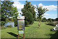
Rules by the Fishpond
An impressive list of do's and don'ts beside Wood Lane fishing lakes. No braid or boilies, if you would be so good, although maggots can be loose fed, which I'm sure they enjoy.
Image: © Des Blenkinsopp
Taken: 5 Oct 2017
0.11 miles
4
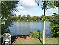
Wood Lane Lake
One of two lakes here used by anglers.
Image: © Des Blenkinsopp
Taken: 5 Oct 2017
0.11 miles
5
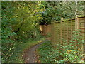
Beeches Way
The path that runs from Wood Lane to Swallow Street near Iver.
Image: © Alan Hunt
Taken: 13 Oct 2012
0.14 miles
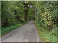
6
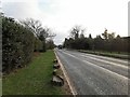
Wood Lane
South bound towards Shreding Green.
Image: © James Emmans
Taken: 9 Jan 2019
0.21 miles