IMAGES TAKEN NEAR TO
Holly Bush Lane, IVER, SL0 0JT
Introduction
This page details the photographs taken nearby to Holly Bush Lane, SL0 0JT by members of the Geograph project.
The Geograph project started in 2005 with the aim of publishing, organising and preserving representative images for every square kilometre of Great Britain, Ireland and the Isle of Man.

There are currently over 7.5m images from over14,400 individuals and you can help contribute to the project by visiting https://www.geograph.org.uk
Image Map
Images are licensed for reuse under creativecommons.org/licenses/by-sa/2.0
Notes
- Clicking on the map will re-center to the selected point.
- The higher the marker number, the further away the image location is from the centre of the postcode.
Image Listing (6 Images Found)
Images are licensed for reuse under creativecommons.org/licenses/by-sa/2.0
Image
Details
Distance
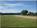
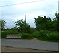
1
Lossie Drive near Hollybush Lane
Hollybush Lane must have been a local rat run and has now blocked off half way.
https://en.wikipedia.org/wiki/Rat_running
Image: © James Emmans
Taken: 9 Jan 2019
0.04 miles
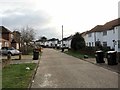
3

Junction of Honeysuckle Close with Hollybush Lane
Image: © Shazz
Taken: 21 May 2013
0.14 miles
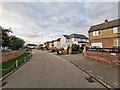
4
Footpath arrives at Billet Lane opposite Hollybush Lane
Image: © Shazz
Taken: 21 May 2013
0.20 miles