IMAGES TAKEN NEAR TO
Slough Road, IVER, SL0 0EA
Introduction
This page details the photographs taken nearby to Slough Road, SL0 0EA by members of the Geograph project.
The Geograph project started in 2005 with the aim of publishing, organising and preserving representative images for every square kilometre of Great Britain, Ireland and the Isle of Man.

There are currently over 7.5m images from over14,400 individuals and you can help contribute to the project by visiting https://www.geograph.org.uk
Image Map
Images are licensed for reuse under creativecommons.org/licenses/by-sa/2.0
Notes
- Clicking on the map will re-center to the selected point.
- The higher the marker number, the further away the image location is from the centre of the postcode.
Image Listing (7 Images Found)
Images are licensed for reuse under creativecommons.org/licenses/by-sa/2.0
Image
Details
Distance
2
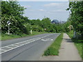
Slough Road near Uxbridge
The sign indicates that the national speed limit applies beyond this point.
In the distance are buildings in Uxbridge town centre.
Image: © Malc McDonald
Taken: 2 Jun 2013
0.08 miles
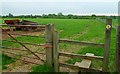
4
Entrance gates on footpath east of Iver Heath
Image: © Shazz
Taken: 21 May 2013
0.13 miles