IMAGES TAKEN NEAR TO
Bangors Road South, IVER, SL0 0AU
Introduction
This page details the photographs taken nearby to Bangors Road South, SL0 0AU by members of the Geograph project.
The Geograph project started in 2005 with the aim of publishing, organising and preserving representative images for every square kilometre of Great Britain, Ireland and the Isle of Man.

There are currently over 7.5m images from over14,400 individuals and you can help contribute to the project by visiting https://www.geograph.org.uk
Image Map
Images are licensed for reuse under creativecommons.org/licenses/by-sa/2.0
Notes
- Clicking on the map will re-center to the selected point.
- The higher the marker number, the further away the image location is from the centre of the postcode.
Image Listing (7 Images Found)
Images are licensed for reuse under creativecommons.org/licenses/by-sa/2.0
Image
Details
Distance
1
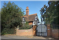
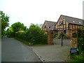
Gate to "Coppins"
Coppins is a large secluded mansion. This is an area for large secluded mansions, most of them, as here, lurking behind tall hedges and fancy gates.
Image: © Des Blenkinsopp
Taken: 5 Oct 2017
0.01 miles
2
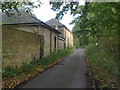
Coppins Lane, Iver
An access road to Coppins Farm from Bangor Road South.
Image: © Alan Hunt
Taken: 13 Oct 2012
0.09 miles
3
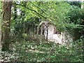
Iver: Overgrown remains of abandoned bungalow
Image: © Rob Emms
Taken: 24 Aug 2017
0.21 miles
4
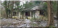
Coppins Farm Cottage
Neglected old cottage
Image: © John Chisholm
Taken: 8 Feb 2021
0.21 miles
5
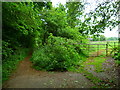
Beeches Way (81)
Here the way narrows to a rough bridleway.
Image: © Shazz
Taken: 21 May 2013
0.23 miles
6
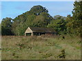
Coppins Farm
One of the outhouses of this derelict farm near Iver.
Image: © Alan Hunt
Taken: 13 Oct 2012
0.24 miles
7
Beeches Way (80)
The way to go is by Love Green Farm.
Image: © Shazz
Taken: 21 May 2013
0.25 miles