IMAGES TAKEN NEAR TO
Bangors Close, IVER, SL0 0AJ
Introduction
This page details the photographs taken nearby to Bangors Close, SL0 0AJ by members of the Geograph project.
The Geograph project started in 2005 with the aim of publishing, organising and preserving representative images for every square kilometre of Great Britain, Ireland and the Isle of Man.

There are currently over 7.5m images from over14,400 individuals and you can help contribute to the project by visiting https://www.geograph.org.uk
Image Map
Images are licensed for reuse under creativecommons.org/licenses/by-sa/2.0
Notes
- Clicking on the map will re-center to the selected point.
- The higher the marker number, the further away the image location is from the centre of the postcode.
Image Listing (38 Images Found)
Images are licensed for reuse under creativecommons.org/licenses/by-sa/2.0
Image
Details
Distance
2
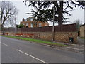
Evreham Road, Iver
The junction of Evreham Road with Bangor Road South.
Image: © Alan Hunt
Taken: 13 Oct 2012
0.06 miles
4
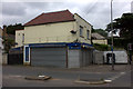
Iver food and wine
Now closed. A sad contrast to the picture from 3 years ago Image
Image: © Robert Eva
Taken: 22 Jun 2017
0.08 miles
5
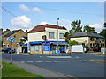
Iver Food & Wine
And a lot else, as well - a typical corner convenience store.
Image: © Robin Webster
Taken: 21 Sep 2014
0.09 miles
6
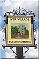
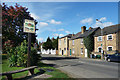
Iver - village sign
The artist has chosen St Peter's Church to illustrate Iver village.
Image: © Stephen McKay
Taken: 15 Aug 2017
0.11 miles
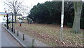
9
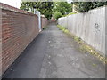
Path from Iver High Street to Barnfield
Image: © David Howard
Taken: 11 May 2014
0.12 miles
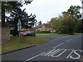
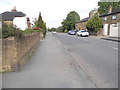
10
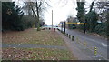
Saxon Court, Iver
Main entrance into Iver Park and Recreation Ground.
Image: © Rob Emms
Taken: 2 Dec 2016
0.13 miles