IMAGES TAKEN NEAR TO
Beech Close, ALDERLEY EDGE, SK9 7LY
Introduction
This page details the photographs taken nearby to Beech Close, SK9 7LY by members of the Geograph project.
The Geograph project started in 2005 with the aim of publishing, organising and preserving representative images for every square kilometre of Great Britain, Ireland and the Isle of Man.

There are currently over 7.5m images from over14,400 individuals and you can help contribute to the project by visiting https://www.geograph.org.uk
Image Map
Images are licensed for reuse under creativecommons.org/licenses/by-sa/2.0
Notes
- Clicking on the map will re-center to the selected point.
- The higher the marker number, the further away the image location is from the centre of the postcode.
Image Listing (12 Images Found)
Images are licensed for reuse under creativecommons.org/licenses/by-sa/2.0
Image
Details
Distance
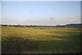
3
The Edge Hockey Centre, Alderley Edge
The home of Alderley Edge Hockey Club, set back from the east side of the B5359.
Image: © Jaggery
Taken: 8 Sep 2014
0.16 miles
4
Development opportunity in Harden Park, Alderley Edge
Fencing encloses the former Yesterdays Nightclub site. A notice states that the approximately
4 acre site has the potential for residential redevelopment subject to consents.
Image: © Jaggery
Taken: 8 Sep 2014
0.17 miles
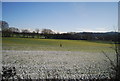
5
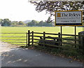
Entrance to The Ryleys Games Field, Alderley Edge
Viewed across the B5359. The Ryleys is a girls and boys preparatory school.
Image: © Jaggery
Taken: 8 Sep 2014
0.18 miles
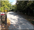
6
Entrance to The Ryleys Games Field
The Ryleys is a girls and boys preparatory school.
Image: © Anthony Parkes
Taken: 21 Aug 2016
0.18 miles
7
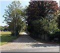
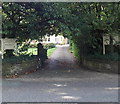
Horseshoe Lane, Alderley Edge
Viewed across Wilmslow Road. The name sign on the right states that
Horseshoe Lane is a private road, not maintained by the local authority.
Image: © Jaggery
Taken: 8 Sep 2014
0.18 miles
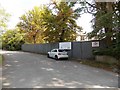
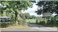
8
Vehicles will be apprehended on a private road in Harden Park, Alderley Edge
Viewed from the public side of a private road. Next to a yellow closed circuit television notice,
a red notice on a fence shows
PRIVATE ROAD No unauthorised access beyond this gate. Vehicles will be apprehended.
Image: © Jaggery
Taken: 8 Sep 2014
0.19 miles
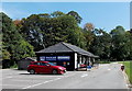
9
Leafy entrance to Alderley Edge Physiotherapy Clinic
The clinic is in Avonmore, Wilmslow Road.
Image: © Jaggery
Taken: 8 Sep 2014
0.20 miles
10

Fenced-off former County Hotel in Alderley Edge
Viewed from the B5359. The County Hotel at the edge of Harden Park closed down in November 2009. The building was originally a Victorian villa. http://www.geograph.org.uk/photo/4160037 to a closer view.
Image: © Jaggery
Taken: 8 Sep 2014
0.21 miles