IMAGES TAKEN NEAR TO
Macclesfield Road, ALDERLEY EDGE, SK9 7BQ
Introduction
This page details the photographs taken nearby to Macclesfield Road, SK9 7BQ by members of the Geograph project.
The Geograph project started in 2005 with the aim of publishing, organising and preserving representative images for every square kilometre of Great Britain, Ireland and the Isle of Man.

There are currently over 7.5m images from over14,400 individuals and you can help contribute to the project by visiting https://www.geograph.org.uk
Image Map
Images are licensed for reuse under creativecommons.org/licenses/by-sa/2.0
Notes
- Clicking on the map will re-center to the selected point.
- The higher the marker number, the further away the image location is from the centre of the postcode.
Image Listing (76 Images Found)
Images are licensed for reuse under creativecommons.org/licenses/by-sa/2.0
Image
Details
Distance
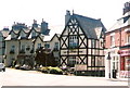
1
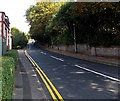
Macclesfield Road, Alderley Edge
The B5087 Macclesfield Road heads ESE away from the centre of the village.
The NW edge of Macclesfield is about 6km ahead.
Image: © Jaggery
Taken: 8 Sep 2014
0.01 miles
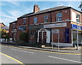
3
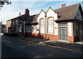
The Old Sorting Office, Alderley Edge
Viewed across Macclesfield Road. An ornate inscription above the doorway on the
left shows ALDERLEY EDGE POST OFFICE. Now the premises of Mobedia digital agency.
Image: © Jaggery
Taken: 8 Sep 2014
0.07 miles
4
St Hilary's Park, Alderley Edge
The southern edge of apartments, viewed from Congleton Road.
Image: © Jaggery
Taken: 8 Sep 2014
0.07 miles
5
Alderley Chiropractic & Physiotherapy, Alderley Edge
Viewed across Chapel Road near the corner of Macclesfield Road.
A sign on the right points left towards Alderley Edge Methodist Church. http://www.geograph.org.uk/photo/4157620
Image: © Jaggery
Taken: 8 Sep 2014
0.07 miles
6
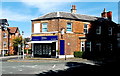
Michael J Chapman estate agents office in Alderley Edge
On the corner of Chapel Road and Macclesfield Road.
Image: © Jaggery
Taken: 8 Sep 2014
0.07 miles
7
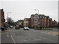
Six lane ends, Alderley Edge
In the days before the bypass inception the view of the roads, here from outside the de Trafford Arms, would have been cluttered with vehicles either whizzing up and down the A34 as it then was or locked in a jam with vehicles negotiating the complex junction.
Image: © Peter Turner
Taken: 26 Mar 2011
0.08 miles
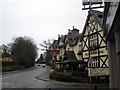
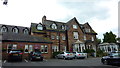
9
The Trafford Arms, Alderley Edge
This hotel is on a busy junction in Alderley Edge, Cheshire. Note the hotel sign reminiscent of place name signs in days of old. The building with the red window frontage nearest the camera is the Thresher wine store.
Image: © Rob K Brettle
Taken: 30 May 2009
0.08 miles
10
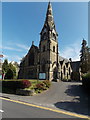
Alderley Edge Methodist Church
The church on the south side of Chapel Road in Alderley Edge dates from 1863.
Alderley Edge Methodist Church is part of the Manchester and Stockport District of the Methodist Church of Great Britain. It is one of six churches in the Alderley Edge and Knutsford Methodist Circuit. The others are in Knutsford, Mobberley, Mottram St Andrew, Over Peover and Snelson.
Image: © Jaggery
Taken: 8 Sep 2014
0.09 miles