IMAGES TAKEN NEAR TO
Quarry Bank Road, WILMSLOW, SK9 4LA
Introduction
This page details the photographs taken nearby to Quarry Bank Road, SK9 4LA by members of the Geograph project.
The Geograph project started in 2005 with the aim of publishing, organising and preserving representative images for every square kilometre of Great Britain, Ireland and the Isle of Man.

There are currently over 7.5m images from over14,400 individuals and you can help contribute to the project by visiting https://www.geograph.org.uk
Image Map
Images are licensed for reuse under creativecommons.org/licenses/by-sa/2.0
Notes
- Clicking on the map will re-center to the selected point.
- The higher the marker number, the further away the image location is from the centre of the postcode.
Image Listing (376 Images Found)
Images are licensed for reuse under creativecommons.org/licenses/by-sa/2.0
Image
Details
Distance
1
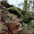
Gnarled beech in a bank
Eroded sandstone bank and a wall seem to be the only things supporting this massive beech tree, in the grounds of Quarry Bank at Styal.
Image: © Peter Barr
Taken: 26 Feb 2014
0.00 miles
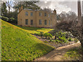
2
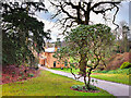
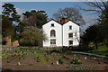
Path to Quarry Bank House
Quarry Bank House was built in 1797 for the owner of the adjacent Quarry Bank Mill, Samuel Greg and his family. It is a Grade II listed building (Historic England List Entry Number:1237686 https://historicengland.org.uk/listing/the-list/list-entry/1237686 ).
Image: © David Dixon
Taken: 6 Mar 2023
0.00 miles
3
Mill Owner's House at Quarry Bank Mill
Quarry Bank House was built in 1797 for the owner of the adjacent Quarry Bank Mill, Samuel Greg and his family. It is a Grade II listed building (Historic England List Entry Number:1237686 https://historicengland.org.uk/listing/the-list/list-entry/1237686 ).
Image: © David Dixon
Taken: 6 Mar 2023
0.00 miles
4
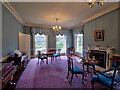
Drawing Room, Quarry Bank House
Quarry Bank House was built in 1797 for the owner of the adjacent Quarry Bank Mill, Samuel Greg and his family. It is a Grade II listed building (Historic England List Entry Number:1237686 https://historicengland.org.uk/listing/the-list/list-entry/1237686 ).
Image: © David Dixon
Taken: 6 Mar 2023
0.00 miles
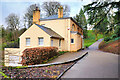
5
Apprentice House
Apprentice House and garden on the Styal Estate.
Image: © Gillian Gillett
Taken: 7 Apr 2007
0.00 miles
6
Mill owners' house, Quarry Bank Mill
Used as the Greg family residence.
Image: © George Evans
Taken: 25 Aug 2009
0.00 miles
7
Mill owner's house, Quarry Bank
Alongside the mill, on the east bank of the River Bollin.
Image: © Christine Johnstone
Taken: 22 Apr 2012
0.00 miles
8
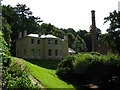
Quarry Bank House and Stone Footbridge
The large building is Quarry Bank House. This was built in 1797 for Samuel Greg, owner of the adjacent Quarry Bank Mill, and his family. It is a Grade II listed building (http://www.britishlistedbuildings.co.uk/en-414951-quarry-bank-house- British Listed Buildings).
The stone footbridge over the River Bollin, in the foreground next to Quarry Bank Mill, was built for the Gregs in 1820. It carries the path to Morley as well as giving access from the mill to mill meadow (from where this photo was taken) and the garden. It is also a Grade II listed building (http://www.britishlistedbuildings.co.uk/en-414952-the-packhorse-bridge- British Listed Buildings).
Image: © David Dixon
Taken: 6 Mar 2017
0.00 miles
9
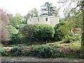
Quarry Bank House
Quarry Bank House was built for Samuel and Hannah Greg in 1797. Samuel Greg was the owner of the adjacent Quarry Bank Mill. The house is a Grade II listed building (http://www.britishlistedbuildings.co.uk/en-414951-quarry-bank-house- British Listed Buildings).
Image: © David Dixon
Taken: 6 Mar 2017
0.00 miles
10
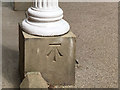
An extremely fine cut benchmark
This fine benchmark is at the base of a pillar by the front door of Quarry Bank House Image The OS description is: PORCH QUARRY BANK HO S FACE.
Image: © Neville Goodman
Taken: 17 Aug 2018
0.00 miles