IMAGES TAKEN NEAR TO
Styal Road, WILMSLOW, SK9 4HP
Introduction
This page details the photographs taken nearby to Styal Road, SK9 4HP by members of the Geograph project.
The Geograph project started in 2005 with the aim of publishing, organising and preserving representative images for every square kilometre of Great Britain, Ireland and the Isle of Man.

There are currently over 7.5m images from over14,400 individuals and you can help contribute to the project by visiting https://www.geograph.org.uk
Image Map
Images are licensed for reuse under creativecommons.org/licenses/by-sa/2.0
Notes
- Clicking on the map will re-center to the selected point.
- The higher the marker number, the further away the image location is from the centre of the postcode.
Image Listing (21 Images Found)
Images are licensed for reuse under creativecommons.org/licenses/by-sa/2.0
Image
Details
Distance
1
Wilmslow Phoenix Sports Club, Styal, Cheshire
Image: © Anthony O'Neil
Taken: 29 Mar 2011
0.03 miles
2
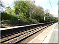
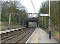
Styal Road by junction of Quarry Bank Road
Image: © Peter Bond
Taken: 23 Jun 2011
0.08 miles
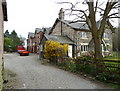

6

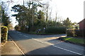
Rose Cottages and Station Road, Styal
The western end of Station Road where it meets Styal Road. The war memorial is opposite.
Image: © Bill Boaden
Taken: 16 Feb 2013
0.20 miles
7
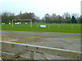
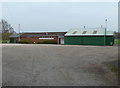
Wilmslow Albion football ground
Oakwood Farm, Styal, Cheshire.
Image: © Anthony O'Neil
Taken: 29 Mar 2011
0.20 miles
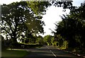
8
Styal Road and the end of Holts Lane
An original route down to Quarry Bank Mill, but cars now have to go a bit further before turning right.
Image: © Bill Boaden
Taken: 16 Feb 2013
0.20 miles
9
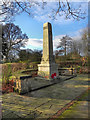
Styal War Memorial
The War Memorial on Styal Road.
Image: © David Dixon
Taken: 19 Feb 2012
0.22 miles