IMAGES TAKEN NEAR TO
Vermont Gardens, CHEADLE, SK8 7RE
Introduction
This page details the photographs taken nearby to Vermont Gardens, SK8 7RE by members of the Geograph project.
The Geograph project started in 2005 with the aim of publishing, organising and preserving representative images for every square kilometre of Great Britain, Ireland and the Isle of Man.

There are currently over 7.5m images from over14,400 individuals and you can help contribute to the project by visiting https://www.geograph.org.uk
Image Map
Images are licensed for reuse under creativecommons.org/licenses/by-sa/2.0
Notes
- Clicking on the map will re-center to the selected point.
- The higher the marker number, the further away the image location is from the centre of the postcode.
Image Listing (7 Images Found)
Images are licensed for reuse under creativecommons.org/licenses/by-sa/2.0
Image
Details
Distance
4
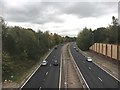
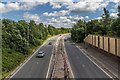
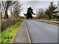
A555 Manchester Airport Eastern Link Road
Looking east from the Hall Moss Lane overbridge
Image: © Graham Hogg
Taken: 25 Oct 2018
0.21 miles
5
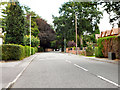
Dairy House Lane, Woodford
Lane leading to government offices and the Total Fitness gymnasium.
Image: © David Dixon
Taken: 2 Apr 2015
0.22 miles
6
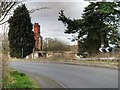
Ruins of Farmhouse, Dairy House Lane
See Image] for a view from 2006.
Image: © David Dixon
Taken: 2 Apr 2015
0.24 miles
7
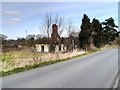
Ruins of Dairy House Farm
See Image] for a view taken in 2006.
Image: © David Dixon
Taken: 2 Apr 2015
0.24 miles