IMAGES TAKEN NEAR TO
Ladybridge Road, CHEADLE, SK8 5BL
Introduction
This page details the photographs taken nearby to Ladybridge Road, SK8 5BL by members of the Geograph project.
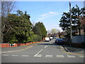
The Geograph project started in 2005 with the aim of publishing, organising and preserving representative images for every square kilometre of Great Britain, Ireland and the Isle of Man.

There are currently over 7.5m images from over14,400 individuals and you can help contribute to the project by visiting https://www.geograph.org.uk
Image Map
Images are licensed for reuse under creativecommons.org/licenses/by-sa/2.0
Notes
- Clicking on the map will re-center to the selected point.
- The higher the marker number, the further away the image location is from the centre of the postcode.
Image Listing (25 Images Found)
Images are licensed for reuse under creativecommons.org/licenses/by-sa/2.0
Image
Details
Distance
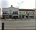
1
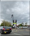
Car park at Cheadle Hulme Shopping Centre
Image: © Eirian Evans
Taken: 10 May 2015
0.14 miles
2
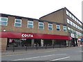
Costa Coffee at Cheadle Hulme Shopping Centre
Image: © Eirian Evans
Taken: 10 May 2015
0.15 miles
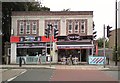
3
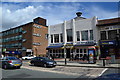
The King's Hall
A JD Wetherspoon Free House, a building with the date 1937. On Station Road, the A5149.
Image: © Peter Barr
Taken: 30 Jul 2012
0.17 miles
4
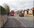
Albert Road
The A5149 at Cheadle Hulme.
Image: © Gerald England
Taken: 2 Mar 2019
0.17 miles
5
Kings Tap, Cheadle Hulme
Originally the village hall with a dance hall upstairs. It was built in 1937. It became a Chinese restaurant and was converted by JD Wetherspoon in 1998 into a cafe bar-style public house called the Kings Hall Image It was bought by Stonegate PubCo in 2016 and renamed by them in February 2017 to the King's Tap.
Image: © Gerald England
Taken: 2 Mar 2019
0.19 miles
6
Matrix Nails and Coco Deli
Directly opposite the pedestrian crossing on Station Road are the Matrix Nail & Beauty salon which also offers training courses http://web.archive.org/web/20130423090317/http://www.matrixnailstrainingacademy.co.uk/ and the Coco Deli http://web.archive.org/web/20120909231827/http://www.cocodeli.co.uk/
Note: Photograph is for record purposes only and the description refers only to the situation at the time the photograph was taken. The photographer has no connection to any of the businesses depicted.
Image: © Gerald England
Taken: 6 Aug 2012
0.20 miles

9
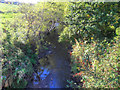
Lady Brook
Lady Brook (also shown as Micker Brook on some maps), seen from Lady Bridge.
Image: © David Dixon
Taken: 29 Sep 2011
0.21 miles
10
South end of Kingsley Drive, Cheadle Hulme
A U shaped road off Queens Road.
Image: © Richard Vince
Taken: 17 Apr 2021
0.22 miles