IMAGES TAKEN NEAR TO
The Pavilions, CHEADLE, SK8 1HE
Introduction
This page details the photographs taken nearby to The Pavilions, SK8 1HE by members of the Geograph project.
The Geograph project started in 2005 with the aim of publishing, organising and preserving representative images for every square kilometre of Great Britain, Ireland and the Isle of Man.

There are currently over 7.5m images from over14,400 individuals and you can help contribute to the project by visiting https://www.geograph.org.uk
Image Map (Loading...)


Getting Data...Please wait
Leaflet Map data © OpenStreetMap
Images are licensed for reuse under creativecommons.org/licenses/by-sa/2.0
Notes
- Clicking on the map will re-center to the selected point.
- The higher the marker number, the further away the image location is from the centre of the postcode.
Image Listing (12 Images Found)
Images are licensed for reuse under creativecommons.org/licenses/by-sa/2.0
Image
Details
Distance

3
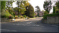
Valley Road, Cheadle
Looking towards its junction with the A5149.
Image: © Trevor Harris
Taken: 14 Aug 2010
0.14 miles
4
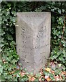
Old Milestone by the former A34 in Belmont, Cheadle
Carved stone post by the UC road (was A34), in parish of Cheadle and Bramhall (Stockport District), Schools Hill, South of junction with Daylesford Road, against low wall, in ivy, on West side of road. Wilmslow stone, erected by the Wilmslow turnpike trust in the 19th century.
Inscription reads:-
: 8 / Miles / to / Manchester / Centre / of / (St Ann's Square) : : Cheadle : : 4¼ / Miles / to / Wilmslow :
Carved benchmark lower right.
Grade II listed.
List Entry Number: 1241803 https://historicengland.org.uk/listing/the-list/list-entry/1241803
Milestone Society National ID: CH_MAWM08
Image: © M Faherty
Taken: 20 Oct 2009
0.16 miles
5
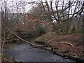
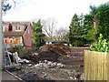
Micker Brook
Known as Lady Brook further upstream. Here Micker Brook passes through woodland behind Cheadle swimming pool as it makes its way to join the River Mersey.
Image: © Keith Williamson
Taken: 1 Feb 2006
0.19 miles
6
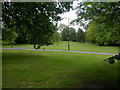
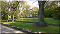
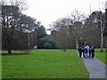
Cheadle, Brookfield Park
Linear park along Micker Brook, owned by Stockport Council.
Image: © Mike Faherty
Taken: 18 May 2009
0.20 miles
8
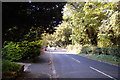
Park beside Micker Brook
Park beside Micker Brook, from the Ladybrook Valley Trail looking towards the A5149 (Wilmslow Road).
Image: © Mike Harris
Taken: 24 Feb 2007
0.22 miles