IMAGES TAKEN NEAR TO
Edale Close, STOCKPORT, SK7 6JZ
Introduction
This page details the photographs taken nearby to Edale Close, SK7 6JZ by members of the Geograph project.
The Geograph project started in 2005 with the aim of publishing, organising and preserving representative images for every square kilometre of Great Britain, Ireland and the Isle of Man.

There are currently over 7.5m images from over14,400 individuals and you can help contribute to the project by visiting https://www.geograph.org.uk
Image Map
Images are licensed for reuse under creativecommons.org/licenses/by-sa/2.0
Notes
- Clicking on the map will re-center to the selected point.
- The higher the marker number, the further away the image location is from the centre of the postcode.
Image Listing (54 Images Found)
Images are licensed for reuse under creativecommons.org/licenses/by-sa/2.0
Image
Details
Distance
2
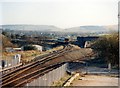
Hazel Grove chord
A cross-country Sprinter unit traverses the chord constructed in the 1980s to allow Manchester-Sheffield trains to run via Stockport. The roller-coaster profile introduced into the up Buxton line is remarkable.
Image: © Peter Whatley
Taken: 29 Oct 1988
0.10 miles
3
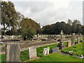
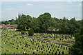
Norbury Parish Churchyard
There are some 4000 graves in the churchyard which was first opened for burials in 1834 and has continued in use right up to the present day. All the spaces available for new burials have now been used. http://www.norburychurch.org.uk/
Image: © Gerald England
Taken: 13 Oct 2012
0.10 miles
4
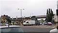
Major road junction
This is the A6 junction with A523 in Hazel Grove, Stockport.
Image: © Dave Smethurst
Taken: 26 Sep 2005
0.10 miles
5
Hazel Grove churchyard, from the railway
Image: © David Long
Taken: 25 Jun 2009
0.11 miles
6
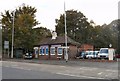
A convenient solution
These former public conveniences on Macclesfield Road opposite the Rising Sun have been converted into offices for the used car dealership "Shallcross Vehicle Solutions".
Image: © Gerald England
Taken: 20 Oct 2012
0.13 miles
7
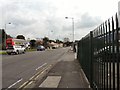
Macclesfield Road
The A523 from Stockport to Macclesfield. On the left is the terminus of 192 bus route from Manchester.
Image: © Gerald England
Taken: 13 Oct 2012
0.13 miles
9
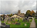
Norbury Parish Church and burial ground
Dedicated to St Thomas, the present church dates mainly from 1833. There are some 4000 graves in the churchyard which was first opened for burials in 1834 and has continued in use right up to the present day. All the spaces available for new burials have now been used http://www.norburychurch.org.uk/
Image: © Gerald England
Taken: 13 Oct 2012
0.14 miles
10
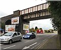
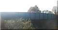
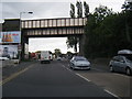
Macclesfield Road Bridge
The bridge over the A523 Macclesfield Road takes the Manchester to Buxton railway line onto the Norbury Viaduct. On the other side of bridge is the terminus of the 192 bus service from Manchester.
Image: © Gerald England
Taken: 13 Oct 2012
0.14 miles