IMAGES TAKEN NEAR TO
Bramhall Lane South, STOCKPORT, SK7 2EN
Introduction
This page details the photographs taken nearby to Bramhall Lane South, SK7 2EN by members of the Geograph project.
The Geograph project started in 2005 with the aim of publishing, organising and preserving representative images for every square kilometre of Great Britain, Ireland and the Isle of Man.

There are currently over 7.5m images from over14,400 individuals and you can help contribute to the project by visiting https://www.geograph.org.uk
Image Map
Images are licensed for reuse under creativecommons.org/licenses/by-sa/2.0
Notes
- Clicking on the map will re-center to the selected point.
- The higher the marker number, the further away the image location is from the centre of the postcode.
Image Listing (35 Images Found)
Images are licensed for reuse under creativecommons.org/licenses/by-sa/2.0
Image
Details
Distance
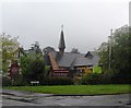
1
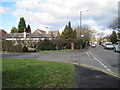
Bramhall Lane South
Bramhall Lane South, junction with Robin's Lane
Image: © Nigel Thompson
Taken: 2 Feb 2013
0.06 miles
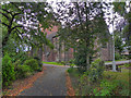
2
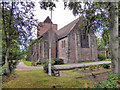
Parish Church of St Michael and All Angels, Bramhall
The parish church at the corner of Robin's Lane and St Michael's Avenue.
Image: © David Dixon
Taken: 24 Aug 2011
0.07 miles
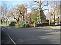
3
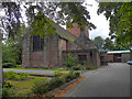
St Michael's Parish Church, Bramhall
The parish church at the corner of Robin's Lane and St Michael's Avenue.
Image: © David Dixon
Taken: 24 Aug 2011
0.08 miles
4
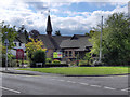
Bramhall United Reformed Church
The United Reformed Church at the corner of Bramhall Lane South and Robin's Lane.
Image: © David Dixon
Taken: 24 Aug 2011
0.08 miles
6
St Michael's Parish Church, Bramhall
The parish church at the corner of Robin's Lane and St Michael's Avenue.
Image: © David Dixon
Taken: 24 Aug 2011
0.08 miles
7
St Michael's and All Angels Parish Church, Bramhall
Image: © Nigel Thompson
Taken: 2 Feb 2013
0.08 miles
8
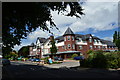
Sunrise Senior Living
On the corner of Dairyground Road and Ladythorn Road, a retirement home for the elderly.
Image: © Peter Barr
Taken: 30 Jul 2012
0.11 miles
9
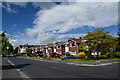
Houses on Dairyground Road, Pownall Green
Link detached properties.
Image: © Peter Barr
Taken: 30 Jul 2012
0.13 miles
10
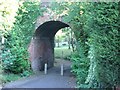
Tunnel under the WCML at Bramhall
Brick arched "bridge" carrying the West Coast Main line over the bottom of Hillbrook Road, Bramhall known locally as "the tunnel". The short path leads through onto Robins Lane. It used to be heavily overgrown but was cleared as part of the renewal work on the line for the West Coast "upgrade" in the 2000s.
Image: © Christopher Styles
Taken: 14 Oct 2012
0.20 miles