IMAGES TAKEN NEAR TO
Brookdale Avenue, STOCKPORT, SK6 7HP
Introduction
This page details the photographs taken nearby to Brookdale Avenue, SK6 7HP by members of the Geograph project.
The Geograph project started in 2005 with the aim of publishing, organising and preserving representative images for every square kilometre of Great Britain, Ireland and the Isle of Man.

There are currently over 7.5m images from over14,400 individuals and you can help contribute to the project by visiting https://www.geograph.org.uk
Image Map
Images are licensed for reuse under creativecommons.org/licenses/by-sa/2.0
Notes
- Clicking on the map will re-center to the selected point.
- The higher the marker number, the further away the image location is from the centre of the postcode.
Image Listing (54 Images Found)
Images are licensed for reuse under creativecommons.org/licenses/by-sa/2.0
Image
Details
Distance
1
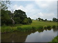
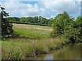
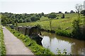
Hill Top Farm, near Hawk Green
From the Peak Forest Canal, near Marple.(also the E2 European Long Distance Route)
"The E2 - a name that fills the mind with a host of inspirational images. Not really, of course, unless you've walked some of the route. It's a dull name for an intriguing footpath which starts in Galway and finishes in Nice. That's the eventual plan anyway, as the first section in Ireland is not actually open.
The "E2" designation is because it is a European Long Distance Path, one of 11 criss-crossing the whole of Europe." are the words of a blogger who has walked the whole route.
Image: © Peter Barr
Taken: 28 Jul 2011
0.14 miles
2
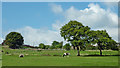
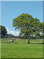
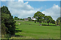
Pasture south-east of Marple, Stockport
Looking from the Peak Forest Canal towards housing in Ridge Road near Hill Top Farm. A few cattle were grazing in one area.
Image: © Roger D Kidd
Taken: 5 Sep 2014
0.17 miles
3
Pasture south-east of Marple, Stockport
Looking from the Peak Forest Canal towards housing in Ridge Road near Hill Top Farm. A few cattle were grazing in one area.
Image: © Roger D Kidd
Taken: 5 Sep 2014
0.17 miles
4
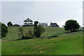
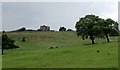
Canalside pasture south-east of Marple, Stockport
Pasture at Hill Top Farm by the Peak Forest Canal is at the southern edge of Marple's housing.
Image: © Roger Kidd
Taken: 7 Sep 2014
0.17 miles
5
Canalside pasture near Marple, Stockport
This is the Peak Forest Canal, looking west towards the Hawk Green housing area.
Image: © Roger Kidd
Taken: 7 Sep 2014
0.17 miles
6
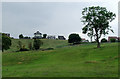
Grazing near Marple, Stockport
At Hilltop Farm by the Peak Forest Canal. The southern edge of Marple's housing can also be seen.
Image: © Roger Kidd
Taken: 7 Sep 2014
0.17 miles
7
Pasture south-east of Marple, Stockport
Looking from the Peak Forest Canal towards a house in Ridge Road south of Hill Top Farm. A few cattle were grazing in one area.
Image: © Roger D Kidd
Taken: 5 Sep 2014
0.18 miles
8
Peak Forest Canal
The Peak Forest canal runs through parkland just outside Marple.
Image: © Richard Webb
Taken: 23 Apr 2004
0.19 miles
9
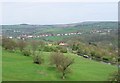
Peak Forest Canal
The canal has been constructed part of the way up the western side of the Goyt valley. The houses seen at the top are on the appropriately named road The Ridge.
Image: © Bill Boaden
Taken: 24 May 2023
0.19 miles
10
Canalside pasture south-east of Marple, Stockport
Pasture at Hill Top Farm by the Peak Forest Canal.
Image: © Roger Kidd
Taken: 7 Sep 2014
0.20 miles