IMAGES TAKEN NEAR TO
Dooley Lane, STOCKPORT, SK6 7HE
Introduction
This page details the photographs taken nearby to Dooley Lane, SK6 7HE by members of the Geograph project.
The Geograph project started in 2005 with the aim of publishing, organising and preserving representative images for every square kilometre of Great Britain, Ireland and the Isle of Man.

There are currently over 7.5m images from over14,400 individuals and you can help contribute to the project by visiting https://www.geograph.org.uk
Image Map
Images are licensed for reuse under creativecommons.org/licenses/by-sa/2.0
Notes
- Clicking on the map will re-center to the selected point.
- The higher the marker number, the further away the image location is from the centre of the postcode.
Image Listing (48 Images Found)
Images are licensed for reuse under creativecommons.org/licenses/by-sa/2.0
Image
Details
Distance
1

Footbridge Over the River Goyt
The footbridge was opened in Chadkirk Country Park on 29 July 2012.
Image: © Ian Rhodes
Taken: 29 Jul 2012
0.02 miles

3

Otterspool Junction Station
Dragon Miniature Railway.
Image: © John Topping
Taken: 14 May 2012
0.06 miles
4
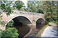
Bredbury and Romiley : Otterspool Bridge
Image: © Ken Bagnall
Taken: 9 Sep 2009
0.07 miles
5
Bredbury and Romiley : Otterspool Bridge
Image: © Ken Bagnall
Taken: 9 Sep 2009
0.07 miles
6

Bredbury and Romiley : Otterspool Bridge
At the sale of the Bredbury estate in 1825, an area lying along the River Goyt was purchased by a Mr Marsden, who built a weir at Otterspool and planned to use water power to develop the valley from there to New Bridge as an industrial estate. However, he failed to secure the water rights. and by the time the lengthy legal proceedings were completed water power had been superseded by steam power.
Image: © Ken Bagnall
Taken: 9 Sep 2009
0.07 miles
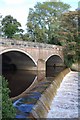
7

Bridge at Otterspool
When the bridge was widened the side wall was dismantled and rebuilt as the wall for the new bridge, seen clearly in the photo.
Image: © Peter Fuller
Taken: 19 Mar 2008
0.07 miles
8

Goyt through trees
River Goyt viewed through trees from Footpath 62M.
Image: © Dave Dunford
Taken: 8 Apr 2017
0.08 miles
9

Otterspool Bridge, weir and Stockport Hydro
Stockport Hydro alongside the weir on the River Goyt. The weir was built for a much earlier cotton mill that was never constructed.
The two Archimedes screws are named Thunder and Lightning. Fish ladder to the left.
Fuller description of the Stockport hydro scheme at Otterspool Weir, Manchester's first community-owned hydro-electric project, is here; http://www.marple-uk.com/stockport-hydro/index.htm
Image: © Chris Morgan
Taken: 3 Jan 2022
0.08 miles
10

Weir at Otterspool
One of a series of weirs between Otterspool and Marple along the River Goyt.
Image: © Peter Fuller
Taken: 19 Mar 2008
0.08 miles