IMAGES TAKEN NEAR TO
Turf Lea Fold, STOCKPORT, SK6 7HA
Introduction
This page details the photographs taken nearby to Turf Lea Fold, SK6 7HA by members of the Geograph project.
The Geograph project started in 2005 with the aim of publishing, organising and preserving representative images for every square kilometre of Great Britain, Ireland and the Isle of Man.

There are currently over 7.5m images from over14,400 individuals and you can help contribute to the project by visiting https://www.geograph.org.uk
Image Map (Loading...)


Getting Data...Please wait
Leaflet Map data © OpenStreetMap
Images are licensed for reuse under creativecommons.org/licenses/by-sa/2.0
Notes
- Clicking on the map will re-center to the selected point.
- The higher the marker number, the further away the image location is from the centre of the postcode.
Image Listing (35 Images Found)
Images are licensed for reuse under creativecommons.org/licenses/by-sa/2.0
Image
Details
Distance
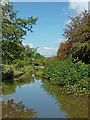
1
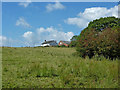
Cheshire pasture north-east of High Lane
Farm land by Slack Hall Farm, seen from the Upper Peak Canal at Turflea Narrows.
Image: © Roger Kidd
Taken: 7 Sep 2014
0.11 miles
2
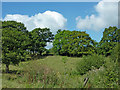
Pasture and trees north-east of High Lane, Cheshire
Farm land by Slack Hall Farm, seen from the Upper Peak Canal at Turflea Narrows.
Image: © Roger Kidd
Taken: 7 Sep 2014
0.14 miles
3
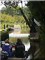
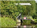
Bridge 22, Peak Forest Canal
One of a pair of lifting bridges on this section of the canal; it serves a farm track and footpath above Strines.
Image: © Alan Murray-Rust
Taken: 15 Sep 2009
0.15 miles
4
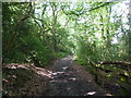
Bridleway near the Peak Forest Canal
Between Disley and Marple.
Image: © Peter Barr
Taken: 28 Jul 2011
0.15 miles
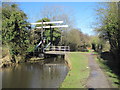
5
Turflea Lift Bridge - Lifted. Upper Peak Forest Canal, Cheshire
Image: © Roger D Kidd
Taken: 26 Aug 2007
0.15 miles
6
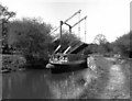
Turflea Lift Bridge, Peak Forest Canal
Confusingly on this canal, these bridges are sometimes referred to as 'swing' bridges.
Image: © Dr Neil Clifton
Taken: 13 Apr 1981
0.15 miles
7
Lift Bridge on Peak Forest Canal
On a bright winter's day, looking north
Image: © Nigel Thompson
Taken: 2 Feb 2013
0.16 miles
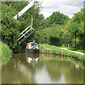
8
Upper Peak Canal north-east of High Lane in Cheshire
This is the Upper Peak Forest Canal, looking north towards Marple Junction. The narrow section shows where a bridge used to be. Any information about it will be appreciated. Two hundred metres ahead is Turflea Lift Bridge, No 22.
Image: © Roger Kidd
Taken: 7 Sep 2014
0.16 miles
9
Lift Bridge; bridge no. 22, Peak Forest Canal
Stop sign for unwary narrowboats.
Image: © Peter Barr
Taken: 28 Jul 2011
0.16 miles
10
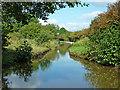
Upper Peak Canal north-east of High Lane in Cheshire
This is the Upper Peak Forest Canal, looking north towards Marple Junction. The narrow section shows where a bridge used to be. Any information about it will be appreciated. About 150 metres ahead is Turflea Lift Bridge, No 22.
Image: © Roger Kidd
Taken: 7 Sep 2014
0.16 miles