IMAGES TAKEN NEAR TO
Plucksbridge Road, STOCKPORT, SK6 7DY
Introduction
This page details the photographs taken nearby to Plucksbridge Road, SK6 7DY by members of the Geograph project.
The Geograph project started in 2005 with the aim of publishing, organising and preserving representative images for every square kilometre of Great Britain, Ireland and the Isle of Man.

There are currently over 7.5m images from over14,400 individuals and you can help contribute to the project by visiting https://www.geograph.org.uk
Image Map
Images are licensed for reuse under creativecommons.org/licenses/by-sa/2.0
Notes
- Clicking on the map will re-center to the selected point.
- The higher the marker number, the further away the image location is from the centre of the postcode.
Image Listing (66 Images Found)
Images are licensed for reuse under creativecommons.org/licenses/by-sa/2.0
Image
Details
Distance
1

Old Milemarker by the Peak Forest Canal, Marple parish
Stone Milemarker by the Peak Forest Canal, in parish of Marple (Stockport District). Next to towpath North of Lower Ridge Farm.
Surveyed
Milestone Society National ID: PFC-09
Image: © Milestone Society
Taken: Unknown
0.03 miles
2
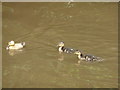
Cute, aren't they?
Irresistible, three little ducklings on the Peak Forest Canal.
Image: © Peter Barr
Taken: 28 Jul 2011
0.03 miles
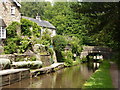
3
Peak Forest Canal south-east of Marple, Stockport
This is the Peak Forest Canal, looking north towards Marple.
Image: © Roger Kidd
Taken: 7 Sep 2014
0.08 miles
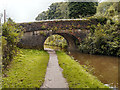
5
Rawton Walls Bridge south-east of Marple, Stockport
Rawton Walls Bridge is No 21 across the Upper Peak Forest Canal. It carries Plucksbridge Lane, but Hollinswood Lane off to the left is no longer continuous for vehicles as far as Ridge End.
Image: © Roger Kidd
Taken: 7 Sep 2014
0.09 miles
6
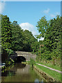
Rawton Walls Bridge south-east of Marple, Stockport
Rawton Walls Bridge is No 21 across the Upper Peak Forest Canal. It carries Plucksbridge Lane, but Hollinswood Lane off to the left is no longer continuous for vehicles as far as Ridge End.
Image: © Roger Kidd
Taken: 7 Sep 2014
0.09 miles
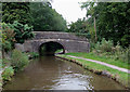
7

Rawton Walls Bridge south-east of Marple, Stockport
Bridge No 21 across the Peak Forest Canal links a narrow lane called Plucksbridge Road with another one called Hollinwood Lane.
Image: © Roger D Kidd
Taken: 5 Sep 2014
0.09 miles
8
Rawton Walls Bridge south-east of Marple, Stockport
Bridge No 21 across the Peak Forest Canal links a narrow lane called Plucksbridge Road with another one called Hollinwood Lane.
Image: © Roger D Kidd
Taken: 5 Sep 2014
0.09 miles
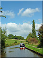
9
Narrowboat approaching Bridge 21
Peak Forest Canal, south of Marple.
Image: © Peter Barr
Taken: 28 Jul 2011
0.10 miles
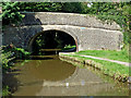
10
![Rawton Walls Bridge [No 21], from the south-east](https://s0.geograph.org.uk/geophotos/03/98/81/3988176_7a6b1028_120x120.jpg)
Rawton Walls Bridge [No 21], from the south-east
Carrying Hollinwood Lane over the Peak Forest Canal.
Image: © Christine Johnstone
Taken: 11 May 2014
0.10 miles