IMAGES TAKEN NEAR TO
Faywood Drive, STOCKPORT, SK6 7DF
Introduction
This page details the photographs taken nearby to Faywood Drive, SK6 7DF by members of the Geograph project.
The Geograph project started in 2005 with the aim of publishing, organising and preserving representative images for every square kilometre of Great Britain, Ireland and the Isle of Man.

There are currently over 7.5m images from over14,400 individuals and you can help contribute to the project by visiting https://www.geograph.org.uk
Image Map
Images are licensed for reuse under creativecommons.org/licenses/by-sa/2.0
Notes
- Clicking on the map will re-center to the selected point.
- The higher the marker number, the further away the image location is from the centre of the postcode.
Image Listing (264 Images Found)
Images are licensed for reuse under creativecommons.org/licenses/by-sa/2.0
Image
Details
Distance
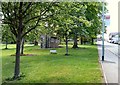
2
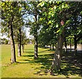
Avenue of Trees
Trees on the recreation ground alongside Arkwright Road.
Image: © Gerald England
Taken: 12 May 2009
0.07 miles
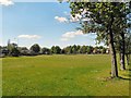
3
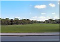
Marple Recreation Ground
Looking from Oldknow Road towards Arkwright Road and Strines Road.
Image: © Gerald England
Taken: 12 May 2009
0.09 miles
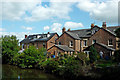
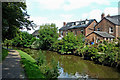
4
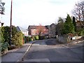
Canalside housing near Marple, Stockport
The housing is in St Martin's Road, which runs alongside the Peak Forest Canal by the Marple lock flight.
Image: © Roger Kidd
Taken: 7 Sep 2014
0.09 miles
5
Golf and Horse Riding Prohibited
On the recreation ground off Oldknow Road.
Image: © Gerald England
Taken: 12 May 2009
0.09 miles
6
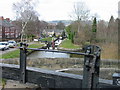
Marple locks
Marple locks on the Peak Forest Canal
Image: © Phil Eptlett
Taken: 13 Mar 2005
0.09 miles
7
Marple Recreation Ground
Looking towards Oldknow Road.
Image: © Gerald England
Taken: 12 May 2009
0.09 miles
8
Canalside housing near Marple, Stockport
The housing is in St Martin's Road, which runs alongside the Peak Forest Canal by the Marple lock flight.
Image: © Roger Kidd
Taken: 7 Sep 2014
0.10 miles
9
Peak Forest Canal east of Marple, Stockport
This shows the Peak Forest Canal between Locks 11 and 12 of the Marple flight. The housing is in St Martin's Road.
Image: © Roger Kidd
Taken: 7 Sep 2014
0.10 miles
10
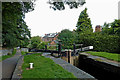
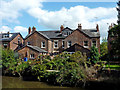
Peak Forest Canal at Marple Locks No 12, Stockport
Lock No 12. The housing is in St Martin's Road.
The Marple flight on the Peak Forest Canal consists of sixteen deep locks in a mile. The total fall (or rise) provided is 209ft 6in (almost 64 metres). The canal was opened to navigation by 1796 but not enough money remained to build these locks. A temporary tramway was installed and used until 1804, when the locks were completed.
Image: © Roger Kidd
Taken: 7 Sep 2014
0.10 miles