IMAGES TAKEN NEAR TO
Suttons Lane, STOCKPORT, SK6 7BJ
Introduction
This page details the photographs taken nearby to Suttons Lane, SK6 7BJ by members of the Geograph project.
The Geograph project started in 2005 with the aim of publishing, organising and preserving representative images for every square kilometre of Great Britain, Ireland and the Isle of Man.

There are currently over 7.5m images from over14,400 individuals and you can help contribute to the project by visiting https://www.geograph.org.uk
Image Map (Loading...)


Getting Data...Please wait
Leaflet Map data © OpenStreetMap
Images are licensed for reuse under creativecommons.org/licenses/by-sa/2.0
Notes
- Clicking on the map will re-center to the selected point.
- The higher the marker number, the further away the image location is from the centre of the postcode.
Image Listing (335 Images Found)
Images are licensed for reuse under creativecommons.org/licenses/by-sa/2.0
Image
Details
Distance
1
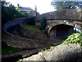
Turnover Bridge
A beautiful example of a Turnover or Roving bridge.
A classic case of 'purpose creating design', these bridges allowed a horse to change towpath sides without having to be unhitched from the boat it was pulling. This one is at the point where the Macclesfield Canal joins or leaves the Peak Forest Canal in Marple.
Image: © Howard Selina
Taken: Unknown
0.02 miles
3
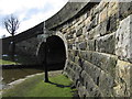
Bridge 1 on the Macclesfield Canal
At this point the Macclesfield canal joins the Peak Forest canal, it is part of the Cheshire ring.
Image: © Dave Croker
Taken: 31 Mar 2013
0.03 miles
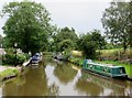
4
Peak Forest Canal at Marple
This is at the top of the series of Marple Locks. Ahead is the valley of the River Goyt.
Image: © Bill Boaden
Taken: 24 May 2023
0.03 miles
5
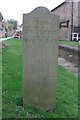
Old milemarker by the Macclesfield Canal, Marple
Milemarker by the Macclesfield Canal, in parish of Marple (Stockport District).
Inscription reads:-
From
Hall Green
26¼ Miles
To be surveyed
Milestone Society National ID: MAC-00
Image: © Milestone Society
Taken: Unknown
0.03 miles
6

Canal Boundary Stone, Marple Junction
Between Lockside/Bridge and Suttons Lane. It would mark the boundary of canal jurisdiction.
Milestone Society National ID: CH_MCMAR01em
Image: © Mr Red
Taken: 23 Aug 2021
0.03 miles
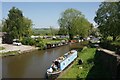
7

Macclesfield Canal
The start of the Macclesfield Canal.
Image: © Gerald England
Taken: 18 Aug 2010
0.03 miles
8

Macclesfield Canal
The end of the Macclesfield Canal. Beyond the bridge lies the Peak Forest Canal.
Image: © Gerald England
Taken: 18 Aug 2010
0.03 miles
9

Marple Canal Basin
Canal basin at the end of the Macclesfield canal.
Image: © Gerald England
Taken: 18 Aug 2010
0.03 miles
10
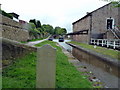
Macclesfield Canal at Marple Junction
The Macclesfield Canal runs from here (the junction is with the Peak Forest Canal) for 26.25 miles to Hall Green where it joins the Trent & Mersey Canal..
Image: © Graham Hogg
Taken: 16 May 2011
0.03 miles