IMAGES TAKEN NEAR TO
Marple Place, STOCKPORT, SK6 6FU
Introduction
This page details the photographs taken nearby to Marple Place, SK6 6FU by members of the Geograph project.
The Geograph project started in 2005 with the aim of publishing, organising and preserving representative images for every square kilometre of Great Britain, Ireland and the Isle of Man.

There are currently over 7.5m images from over14,400 individuals and you can help contribute to the project by visiting https://www.geograph.org.uk
Image Map (Loading...)


Getting Data...Please wait
Leaflet Map data © OpenStreetMap
Images are licensed for reuse under creativecommons.org/licenses/by-sa/2.0
Notes
- Clicking on the map will re-center to the selected point.
- The higher the marker number, the further away the image location is from the centre of the postcode.
Image Listing (375 Images Found)
Images are licensed for reuse under creativecommons.org/licenses/by-sa/2.0
Image
Details
Distance
1
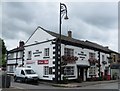
The Navigation
A Robinson's pub close to the canal in Marple.
Image: © philandju
Taken: 31 Jul 2017
0.01 miles
2
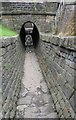
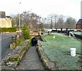
The horse tunnel
The tunnel was used to lead the unhitched barge horses under the B6101.
Image: © philandju
Taken: 31 Jul 2017
0.02 miles
3
Marple - The Navigation
Robinson's pub on Stockport Road.
Image: © Dave Bevis
Taken: 15 Mar 2014
0.02 miles
4
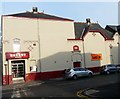
Regent Cinema
The Regent Cinema on Stockport Road, Marple dates from 1878 and is still operating.
Image: © Gerald England
Taken: 15 Dec 2008
0.02 miles
5
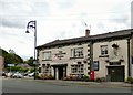
The Navigation
The Navigation dates from around 1790 being built to serve the navvies or Navigation Engineers that built the Peak Forest Navigation, known today as the Peak Forest Canal.
It stands close to clock #13, one of 16 Locks that raise the canal by more than 200 feet over about 1 mile in length. It is claimed that in order to get the locks finished quickly and for his boats to be the first to use the canal, Samuel Oldknow, a local mill owner gave the navvies possets, a milk drink curdled with Ale and often spiced, supplied by the Navigation Pub, as an incentive to work harder. The bridge next to the Navigation is known as Posset Bridge.
It is currently owned by Robinsons Brewery.
Image
Image: © Gerald England
Taken: 23 Jul 2015
0.03 miles
6
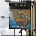
Sign of the Navigation
Sign for the Navigation Image
Image: © Gerald England
Taken: 23 Jul 2015
0.03 miles
7
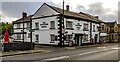
The Navigation
The Navigation public house on Station Road in Marple.
Image: © Peter McDermott
Taken: 1 Jan 2022
0.03 miles
8
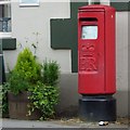
EIIR postbox (SK6 87)
Outside the Navigation Image
Image: © Gerald England
Taken: 23 Jul 2015
0.03 miles
9
Marple Lock #13
Lock number 13 (of 16) on the Peak Forest Canal at Marple. The cobbled towpath goes through an underpass of Stockport Road.
Image: © Gerald England
Taken: 15 Dec 2008
0.03 miles
10
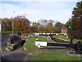
Lock 13 at Marple
Part of the flight of locks at Stockport Road. The tunnel is for towpath users to pass under the road
Image: © Raymond Knapman
Taken: 2 Nov 2011
0.03 miles