IMAGES TAKEN NEAR TO
Hyde Road, STOCKPORT, SK6 1PF
Introduction
This page details the photographs taken nearby to Hyde Road, SK6 1PF by members of the Geograph project.
The Geograph project started in 2005 with the aim of publishing, organising and preserving representative images for every square kilometre of Great Britain, Ireland and the Isle of Man.

There are currently over 7.5m images from over14,400 individuals and you can help contribute to the project by visiting https://www.geograph.org.uk
Image Map
Images are licensed for reuse under creativecommons.org/licenses/by-sa/2.0
Notes
- Clicking on the map will re-center to the selected point.
- The higher the marker number, the further away the image location is from the centre of the postcode.
Image Listing (148 Images Found)
Images are licensed for reuse under creativecommons.org/licenses/by-sa/2.0
Image
Details
Distance
1
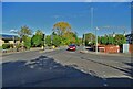
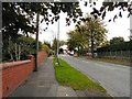
Junction of Hyde Road and Pennine Road, Woodley
Image: © Neil Theasby
Taken: 18 Oct 2022
0.02 miles
2
Poleacre Lane, Woodley (2)
At the junction with the A560 Hyde Road, at the Hyde end. Image
Image: © John Topping
Taken: 18 Oct 2012
0.02 miles
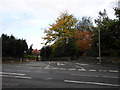
3
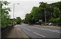
Hyde Road
The A560 from Stockport from just past Pennine Road Image opposite the junction with Poleacre Lane.
Image: © Gerald England
Taken: 5 Oct 2009
0.07 miles
4
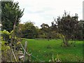
Woodley Fields
Fields at the boundary of Stockport and Tameside Metropolitan Boroughs.
Image: © Gerald England
Taken: 5 Oct 2009
0.07 miles
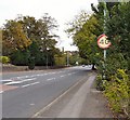
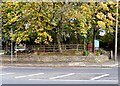
5
Pennine Road
The road to Greave and Romiley from Hyde.
Image: © Gerald England
Taken: 5 Oct 2009
0.08 miles
6
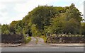
Track to Long Acre Farm
On the Stockport side of the boundary with Tameside.
Image: © Gerald England
Taken: 3 Oct 2009
0.09 miles
7
Werneth Bredbury Boundary
In the wall between the entrances to the Joshua Bradley Image and the Bluebell Centre a stoneImage marks the boundary between the townships of Werneth and Bredbury (now between the Metropolitan Boroughs of Tameside and Stockport).
Image: © Gerald England
Taken: 3 Oct 2009
0.10 miles
8
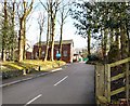
Bluebell Centre
Craft centre and restaurant next door to the Joshua Bradley Image on Stockport Road.
Image: © Gerald England
Taken: 19 Feb 2010
0.11 miles
9
Entering Tameside from Stockport on the A560
Hyde Road becomes Stockport Road at this point. On the right is the Bluebell Centre which provides conference facilities.
Image: © Bill Boaden
Taken: 9 Jun 2010
0.11 miles
10
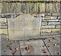
Werneth Bredbury Boundary Stone
Set into the wall of what is now the Joshua Bradley Image public house is the Grade II listed https://historicengland.org.uk/listing/the-list/list-entry/1319492?section=official-list-entry ancient boundary stone between the townships of Werneth and Bredbury.
Milestone Society National ID: CH_WERBRE01pb
Image: © Gerald England
Taken: 3 Oct 2009
0.11 miles