IMAGES TAKEN NEAR TO
George Lane, STOCKPORT, SK6 1DJ
Introduction
This page details the photographs taken nearby to George Lane, SK6 1DJ by members of the Geograph project.
The Geograph project started in 2005 with the aim of publishing, organising and preserving representative images for every square kilometre of Great Britain, Ireland and the Isle of Man.

There are currently over 7.5m images from over14,400 individuals and you can help contribute to the project by visiting https://www.geograph.org.uk
Image Map
Images are licensed for reuse under creativecommons.org/licenses/by-sa/2.0
Notes
- Clicking on the map will re-center to the selected point.
- The higher the marker number, the further away the image location is from the centre of the postcode.
Image Listing (62 Images Found)
Images are licensed for reuse under creativecommons.org/licenses/by-sa/2.0
Image
Details
Distance
1
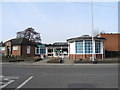
Bredbury Library
Situated on George Lane (A627).
Image: © John Topping
Taken: 4 Mar 2013
0.03 miles
2
Bredbury Library
The original library on George Lane opened in 1937, and the capacity was doubled by extensions in 1962, comprising a children's room and reference room. The latter, now used as a community meeting room, is a dodecahedral annexe, erected mainly out of funds collected locally, as a War Memorial for World War II, and contains memorial windows designed by a local artist and a Book of Remembrance for the dead in both World Wars. Further substantial extensions and alterations, including the conversion of the War Memorial room into an exhibition and lecture room, were completed in 1970.
Image: © Gerald England
Taken: 21 May 2015
0.04 miles
3

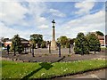
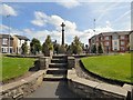
Bredbury & Romiley War Memorial
At the top of Barrack Hill.
Image: © Gerald England
Taken: 2 Aug 2010
0.05 miles
5
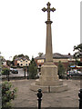
War Memorial, Bredbury and Romiley
The Bredbury and Romiley War Memorial is in a small grassed circle at the top of Barrack Hill, at the junction of Kings Road, George Lane and Berrycroft Lane. In this view, Kings Road and Ruskin Grove are behind the memorial.
See Image]
Image: © David Dixon
Taken: 10 Jun 2010
0.06 miles
6
Bredbury and Romiley War Memorial Dedication
The base of the cross of Image
Image: © David Dixon
Taken: 10 Jun 2010
0.06 miles
7
Bredbury & Romiley War Memorial
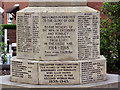
Bredbury & Romiley War Memorial consists of a stone cross at the junction of George Lane and Berrycroft Lane.
THIS CROSS IS ERECTED
TO THE GLORY OF GOD
AND TO THE MEMORY OF THE
MEN OF BREDBURY AND ROMILEY
WHO LAID DOWN THEIR LIVES
IN THE GREAT WAR,
1914 - 1918.
"Their name liveth for ever more".
A full list of names engraved thereon can be found on Carls Cam: http://www.carlscam.com/romiley/warmem.htm
Image: © Gerald England
Taken: 21 May 2015
0.06 miles
8
Bredbury & Romiley War Memorial
Bredbury & Romiley War Memorial consists of a stone cross at the junction of George Lane and Berrycroft Lane.
THIS CROSS IS ERECTED
TO THE GLORY OF GOD
AND TO THE MEMORY OF THE
MEN OF BREDBURY AND ROMILEY
WHO LAID DOWN THEIR LIVES
IN THE GREAT WAR,
1914 - 1918.
"Their name liveth for ever more".
A full list of names engraved thereon can be found on Carls Cam: http://www.carlscam.com/romiley/warmem.htm
Image: © Gerald England
Taken: 21 May 2015
0.06 miles
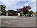
9
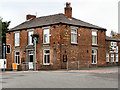
Cow and Calf
The Cow and Calf, at the corner of School Brow and Barrack Hill.
Image: © David Dixon
Taken: 10 Jun 2010
0.08 miles
10
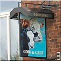
Sign of the Cow & Calf
Sign for the Cow & Calf Image
Image: © Gerald England
Taken: 21 May 2015
0.08 miles