IMAGES TAKEN NEAR TO
Brigadier Road, STOCKPORT, SK5 8LW
Introduction
This page details the photographs taken nearby to Brigadier Road, SK5 8LW by members of the Geograph project.
The Geograph project started in 2005 with the aim of publishing, organising and preserving representative images for every square kilometre of Great Britain, Ireland and the Isle of Man.

There are currently over 7.5m images from over14,400 individuals and you can help contribute to the project by visiting https://www.geograph.org.uk
Image Map
Images are licensed for reuse under creativecommons.org/licenses/by-sa/2.0
Notes
- Clicking on the map will re-center to the selected point.
- The higher the marker number, the further away the image location is from the centre of the postcode.
Image Listing (40 Images Found)
Images are licensed for reuse under creativecommons.org/licenses/by-sa/2.0
Image
Details
Distance
1
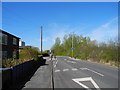
Blackberry Lane, Brinnington
Heading West-northwest.
Image: © John Topping
Taken: 2 May 2013
0.05 miles
2
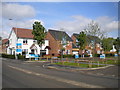
New houses, Cadet Street, Brinnington
Part of a new housing development off the north side of Blackberry Lane, some of which appears to be occupied.
Image: © Richard Vince
Taken: 12 May 2018
0.05 miles
3

North western end of Lapwing Lane, Brinnington
Where it meets Blackberry Lane.
Image: © Richard Vince
Taken: 12 May 2018
0.10 miles
4
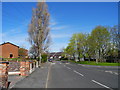
Blackberry Lane, Brinnington
Heading north-west.
Image: © John Topping
Taken: 2 May 2013
0.10 miles
5
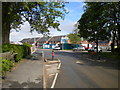
Blackberry Lane, Brinnington
Winding its way around the northern edge of this estate. New housing is under construction ahead.
Image: © Richard Vince
Taken: 12 May 2018
0.11 miles
6
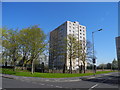
Brecon Towers, Brinnington
Image: © John Topping
Taken: 2 May 2013
0.12 miles
7
West end of loop off Blackberry Lane, Brinnington
Approaching the main part of Blackberry Lane.
Image: © Richard Vince
Taken: 12 May 2018
0.13 miles
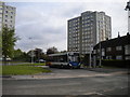
8

Approaching railway bridge, Blackberry Lane, Brinnington
This narrow bridge, which presumably predates the housing development either side of it, carries Blackberry Lane across the direct railway line from New Mills to Manchester, a little way north west of Brinnington station.
Image: © Richard Vince
Taken: 12 May 2018
0.14 miles
9
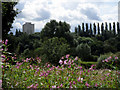
Tame Valley
Looking across the Tame Valley towards Brinnington, one of three tower blocks is visible on the horizon.
Image: © Stephen Burton
Taken: 13 Aug 2019
0.14 miles
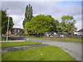
10
Bus turning circle, Holtwood Walk, Brinnington (1)
This turning circle, between two parts of Blackberry Lane (which bifurcates just out of frame to the left), now functions merely as an overengineered bus layby, as Stagecoach Manchester route 325 serves this part of Brinnington with a one way loop. 37157, one of that operator's fleet of Alexander Dennis Enviro 200s, loads before heading back to Stockport town centre.
Image: © Richard Vince
Taken: 12 May 2018
0.14 miles