IMAGES TAKEN NEAR TO
Deniston Road, STOCKPORT, SK4 4RF
Introduction
This page details the photographs taken nearby to Deniston Road, SK4 4RF by members of the Geograph project.
The Geograph project started in 2005 with the aim of publishing, organising and preserving representative images for every square kilometre of Great Britain, Ireland and the Isle of Man.

There are currently over 7.5m images from over14,400 individuals and you can help contribute to the project by visiting https://www.geograph.org.uk
Image Map
Images are licensed for reuse under creativecommons.org/licenses/by-sa/2.0
Notes
- Clicking on the map will re-center to the selected point.
- The higher the marker number, the further away the image location is from the centre of the postcode.
Image Listing (23 Images Found)
Images are licensed for reuse under creativecommons.org/licenses/by-sa/2.0
Image
Details
Distance
1
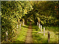
Peel Moat
Wooded path behind the (former) college and recreation centre at Peel Moat.
Image: © David Dixon
Taken: 6 Oct 2012
0.11 miles
2
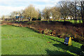
Heaton Moor Park
Quite a small park but reasonably well equipped.
Image: © Bill Boaden
Taken: 10 Jan 2020
0.13 miles
3
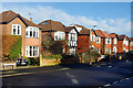
Buckingham Road, Heaton Moor
The houses here, beyond the core of Heaton Moor that was developed in Victorian times, date probably from the late 1930s. They are detached and would have been considered upmarket when they were built; they remain smart today.
Image: © Stephen McKay
Taken: 30 Dec 2024
0.13 miles
4
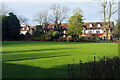
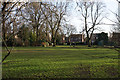
Heaton Moor Park
This view shows the bowling green at the north end of the four acre park. The park was opened in 1897 on land donated by the 4th Baron Egerton of Tatton. A nearby plaque commemorates the efforts of Sir Thomas Thornhill Shann described as a prime mover in creating the park.
Image: © Stephen McKay
Taken: 30 Dec 2024
0.13 miles
5
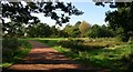
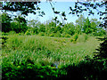
Peel Moat
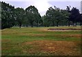
A view of Peel Moat on Heaton Moor Golf Course. Looking roughly west. The moat is now often dry and nothing remains on the small central island. It is a small rectangular moat, described by 19th Century sources as having once enclosed a square fortified tower. The central island is the sunlit patch of grass in the centre of the frame. The moat extends from the shrubs on the rhs of the path, just below the centre of the frame, through the area of "brown" reedy grass then round the island and back to the path. SJ87509247.
Image: © Keith Williamson
Taken: 5 Oct 2005
0.15 miles
6
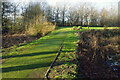
Peel Moat
Peel Moat is the site of a medieval moated house although only the overgrown and waterlogged moat itself has survived. It is now a scheduled ancient monument. A causeway allows access to the moated area and is used by golfers on Heaton Moor golf course to access one of the tees.
Image: © Stephen McKay
Taken: 30 Dec 2024
0.15 miles
8
Peel Moat
Peel Moat is the site of a medieval moated house although only the overgrown and waterlogged moat itself has survived. It is now a scheduled ancient monument. The moated area is now used as part of Heaton Moor golf course for the red tee (ie women's tee) on the 15th hole.
Image: © Stephen McKay
Taken: 30 Dec 2024
0.16 miles
9
Peel Moat, Heaton Chapel
An ancient water-filled trench that provides an oasis for frogs, birds and other wildlife in the midst of Heaton Moor golf course, a more cultivated and sterile environment.
Image: © Slbs
Taken: Unknown
0.16 miles