IMAGES TAKEN NEAR TO
Churwell Avenue, STOCKPORT, SK4 3QE
Introduction
This page details the photographs taken nearby to Churwell Avenue, SK4 3QE by members of the Geograph project.
The Geograph project started in 2005 with the aim of publishing, organising and preserving representative images for every square kilometre of Great Britain, Ireland and the Isle of Man.

There are currently over 7.5m images from over14,400 individuals and you can help contribute to the project by visiting https://www.geograph.org.uk
Image Map
Images are licensed for reuse under creativecommons.org/licenses/by-sa/2.0
Notes
- Clicking on the map will re-center to the selected point.
- The higher the marker number, the further away the image location is from the centre of the postcode.
Image Listing (7 Images Found)
Images are licensed for reuse under creativecommons.org/licenses/by-sa/2.0
Image
Details
Distance
1
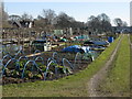
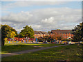
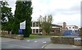
Priestnall Allotments, Heaton Mersey
Allotments behind Priestnall School
Image: © Peter Fuller
Taken: 8 Mar 2010
0.06 miles
2
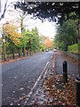
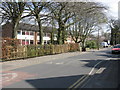
Princes Road
This is an unadopted road, but a few years ago the residents agreed to have it resurfaced, so it is smoother to drive along than many such roads.
Image: © HelenK
Taken: 28 Oct 2011
0.12 miles
3
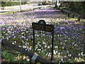
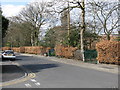
Crocus Corner, Heaton Moor
Spring display at Crocus Corner (Mauldeth Road Conservation Area). This display is followed by a daffodil display.
Image: © Peter Fuller
Taken: 19 Mar 2010
0.17 miles
5
Heaton Mersey - Priestnall Road, looking east
Image: © Peter Whatley
Taken: 1 Apr 2009
0.22 miles
6
Heaton Mersey - Priestnall Road, looking west
Image: © Peter Whatley
Taken: 1 Apr 2009
0.25 miles