IMAGES TAKEN NEAR TO
Sandringham Drive, STOCKPORT, SK4 2DE
Introduction
This page details the photographs taken nearby to Sandringham Drive, SK4 2DE by members of the Geograph project.
The Geograph project started in 2005 with the aim of publishing, organising and preserving representative images for every square kilometre of Great Britain, Ireland and the Isle of Man.

There are currently over 7.5m images from over14,400 individuals and you can help contribute to the project by visiting https://www.geograph.org.uk
Image Map (Loading...)


Getting Data...Please wait
Leaflet Map data © OpenStreetMap
Images are licensed for reuse under creativecommons.org/licenses/by-sa/2.0
Notes
- Clicking on the map will re-center to the selected point.
- The higher the marker number, the further away the image location is from the centre of the postcode.
Image Listing (6 Images Found)
Images are licensed for reuse under creativecommons.org/licenses/by-sa/2.0
Image
Details
Distance
1
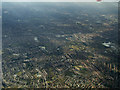
Heaton Norris and Heaton Moor from the air
The cricket and rugby fields at Heaton Norris can be seen as can Heaton Moor Golf Club.
Image: © Thomas Nugent
Taken: 2 Apr 2013
0.15 miles
2
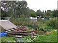
Allotments
Craig Road allotments, Heaton Mersey. SJ87069024.
Image: © Keith Williamson
Taken: 21 Sep 2005
0.18 miles
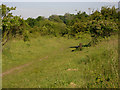
3
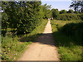
Mersey Vale Nature Park
Public Footpath from Craig Road through the eastern section of the Park
Image: © Peter Fuller
Taken: 15 Jun 2010
0.20 miles
4
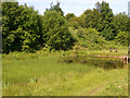
Mersey Vale Nature Park, Pond
Pond in the eastern part of the park
Image: © Peter Fuller
Taken: 15 Jun 2010
0.20 miles
5
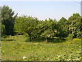
Mersey Vale Nature Park, Orchard
The old orchard with mature trees and in the foreground the new orchard.
Image: © Peter Fuller
Taken: 15 Jun 2010
0.23 miles
6
Mersey Vale Nature Park
Old track of LMS railway line from Manchester to Sheffield
Image: © Peter Fuller
Taken: 15 Jun 2010
0.23 miles