IMAGES TAKEN NEAR TO
Lancashire Hill, STOCKPORT, SK4 1RP
Introduction
This page details the photographs taken nearby to Lancashire Hill, SK4 1RP by members of the Geograph project.
The Geograph project started in 2005 with the aim of publishing, organising and preserving representative images for every square kilometre of Great Britain, Ireland and the Isle of Man.

There are currently over 7.5m images from over14,400 individuals and you can help contribute to the project by visiting https://www.geograph.org.uk
Image Map (Loading...)


Getting Data...Please wait
Leaflet Map data © OpenStreetMap
Images are licensed for reuse under creativecommons.org/licenses/by-sa/2.0
Notes
- Clicking on the map will re-center to the selected point.
- The higher the marker number, the further away the image location is from the centre of the postcode.
Image Listing (221 Images Found)
Images are licensed for reuse under creativecommons.org/licenses/by-sa/2.0
Image
Details
Distance
1
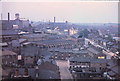
Stockport, 1960
This photograph was taken from the tower of Pendlebury Hall.
Centre right is the junction of Gordon Street and Lancashire Hill. The Albion flour mill is upper left, and the Reddish cotton mills can be seen in the distance.
In the meantime most the Victorian terraced houses here have been cleared.
Image: © Geoff Royle
Taken: Unknown
0.03 miles
2
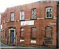
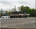
Leemic on Lancashire Hill
Established in 1972, Leemic on the corner of Lancashire Hill and Gordon Street, are a specialised supplier and service provider of Sharp, Samsung & Kyocera digital multifunction printers, copiers and scanning systems.
Image: © Gerald England
Taken: 26 Mar 2014
0.03 miles
3
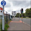
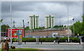
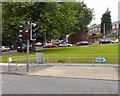
Lancashire Hill
Above the Pelican crossing on Lancashire Hill the road divides intotwo lanes going uphill. The left hand lane is for the A626 to Heaton Chapel and the A6 to Manchester. The right hand lane is for the B6167 to Reddish and the A626 Tiviot Way for Marple going down to the M60 at Portwood.
New mapping now shows the A626 through Heaton Chapel and Portwood as the A6188 but as yet there is no new signage indicating the change of number.
Image: © Gerald England
Taken: 15 Jun 2019
0.05 miles
4
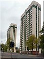
Hanover and Pendelbury Towers
Highrise living on Lancashire Hill.
Image: © Gerald England
Taken: 14 Apr 2011
0.06 miles
5
Nicholsons Arms
Boarded-up pub on Lancashire Hill.
Image: © Gerald England
Taken: 14 Apr 2011
0.07 miles
6
Hanover & Pendlebury Towers, Lancashire Hill
Stockport's iconic tower block housing, bucking the trend to
decry such mid-20th century developments.
The view is from Great Portwood Street looking over the wall which carries the M60 motorway.
Image: © Geoff Royle
Taken: 12 May 2010
0.07 miles
7
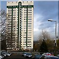
Hanover Towers
One of two highrise apartment blocks on Lancashire Hill viewed from Orphanage Street.
Image: © Gerald England
Taken: 20 Nov 2013
0.08 miles
8
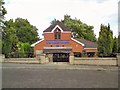
Stockport Christian Spiritualist Church
Situated at 46 Old Road, Lancashire Hill. Church website: http://www.stockportchristianspiritualistchurch.com/
Image: © Gerald England
Taken: 31 Aug 2013
0.08 miles
9
Road crossing for horses
Next to the pedestrian crossing on Lancashire Hill there is a light controlled crossing specifically for horses. A section of the Trans Pennine Trail crosses the B6167 just above Nicholson Street. This type of crossing is known as a Pegasus crossing http://en.wikipedia.org/wiki/Pegasus_crossing
Image: © Gerald England
Taken: 17 Aug 2013
0.08 miles
10
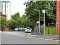
Nicholson Street
A one way street linking Lancashire Hill to Gordon Street. The high-rise building on the left is Hanover Tower. On the right is the former Pendlebury's Orphanage Image now a care home. The lamppost on the right acquired artwork Image in 2015 as part of the second Stockport Arts Trail.
Opposite direction: Image
Image: © Gerald England
Taken: 30 Jun 2016
0.08 miles